 Sandra and Her Baby
A rehabilitated semi-wild orangutan (Pongo abelii) visits the feeding station in Gunung Leuser National Park with her young baby. Never have I felt more like David Attenborough.
You know: in that classic, ground-breaking twelfth episode of Life on Earth (1979), investigating primates and their “Life in the Trees”, where the broadcaster and naturalist finds himself face to face with an adult female mountain gorilla in Rwanda, and turns to talk softly to the cameras.
We were in Asia, not Africa, and they were orangutans, not gorillas, but as I crouched in a jungle clearing, talking softly while a wild primate walked not four feet away from me, I felt that sense of awe and momentary connection. There is something magic about making eye-contact with a sentient ‘forest person’ (orang utan in Malay) in her own environment.
We had been in the jungles of Gunung Leuser National Park in North Sumatra for over three hours, much of it trekking across steep, slippery and narrow trails before our “wild” encounters, and we were having a wonderful morning.
Join me on a rare opportunity to visit a small portion of the UNESCO World Heritage site 1167: ‘The Tropical Rainforest Heritage of Sumatra’.
 Sun on the Bahorok River
Just two weeks before our stay at Bukit Lawang, volcanic Mount Sinabung, about 50 km south as the crow flies, erupted, killing at least 14 people. The volcanic ash still hung thick in the air, like smoke.  Bridge to Bukit Lawang
From our “Ecolodge”, we crossed …  Bathing Huts on the Shore
… over the Bahorok River, where the locals were picnicking and bathing, … Rusty Roofs
… into the small tourist village of Bukit Lawang. Bukit Lawang Locals
Local Indonesians watch our progress through the muddy ‘main street’. Dinghy-Ferry
Access to the Gunung Leuser National Park is by inflatable dinghy. Happy Boatman
The boatman who steered us across the river thought we were pretty entertaining. Sepi and the Ranger
The first orang-utan to visit the feeding station, located a short walk into the park, was seventeen-year-old Sepi. Sepi and her Baby
Her two-and-a-half-year-old baby never left her side. Park Ranger
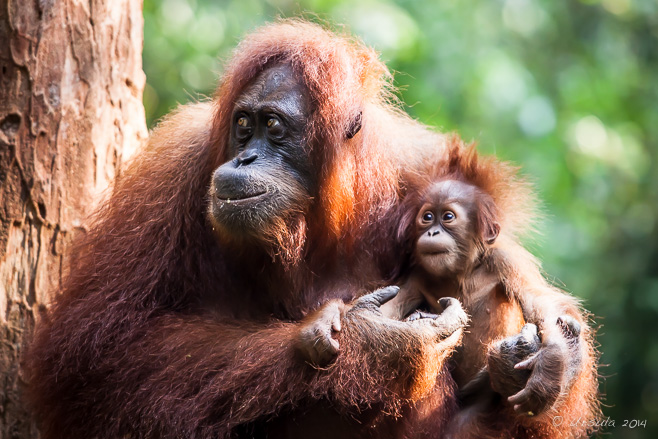
At the Bukit Lawang Rehabilitation Centre, orangutans who had been rescued from captivity were taught the skills necessary to survive in the wild, and released into Gunung Leuser National Park. More than 200 orangutans have been released, and the rangers monitor their progress. The daily feedings at the platform help the orangutans supplement their diets until they can be fully independent. It also allows visitors a view of the semi-wild primates. Sandra and Her Baby
The second orangutan to visit the feeding platform was 40-year-old Sandra with her fourth, and presumably last, baby. Female orangutans have eight-year intervals between babies; for the first four months, infants cling to their mothers, and they are completely dependent for two years. Long-Tailed Macaque
Clearly not the alpha-male, this macaque (Macaca fascicularis) had been in the wars and lost: his facial and leg injuries looked recent. He kept a careful watch as he picked over the scraps left on the feeding platform. Through the Jungle
Our guide asked us if we were feeling ‘strong’, and then led us into the jungle on the not-so-easy path… Lost?
… up hills so steep we were clinging to vines and roots, and through foliage so thick we often lost sight our guides. Thomas Leaf Monkey
Our sharp-eyed guides found some delightful blue-grey and white Thomas’s Langurs (Presbytis thomasi). Thomas Leaf Monkey
Endemic to Sumatra, this vulnerable monkey – like the orangutan – is threatened by habitat loss. Thomas Leaf Monkey
As long as the guides had bananas, the monkeys were happy to visit us. Thomas Leaf Monkey
With their mohawks and whiskers, they are very cute. Official Park Guide
Ayub, one of our guides, was adept at spotting and calling animals. The use of official guides is important for the care and protection of the animals – and for the livelihood of the local community. Swinging In
Orangutans, especially the Sumatran ones, spend nearly all their time in the trees. Ratna swung in to see what our guides had to offer when she heard Ayub calling her. Ratna
She dropped to the ground, and it was wonderful to be so close to her as she walked past me to retrieve a carrot. Juvenile
Ratna’s youngster, a gorgeous little fluff-ball, stayed safely up in the trees. Ratna and her Juvenile
Juveniles are usually weaned at about four years of age – so this one won’t be nursing much longer. Orangutan
The guides had no name for the last orangutan we met because she was born in the wild. During his encounter with the gorillas, (Sir) David Attenborough said: “There is more meaning and mutual understanding in exchanging a glance with a gorilla than with any other animal I know.”
Looking into the gentle brown eyes of the critically endangered Sumatran orangutans, the same could be said.
As soon as we walked out of the park boundaries, we were back in the rubber plantations, much like those we’d seen, mile after mile, on the drive from Medan the day before.
Young Rubber Plantation
Rubber trees stretch into the distance, making it easy to see how challenging it is to protect the remaining small patches of wild habitat.
The less-than-7000 remaining Sumatran orangutans inhabit only a tiny corner of the planet –
We need to help them keep it.
Pictures: 16February2014
Posted in Adventure,Animals,Indonesia,NatureTags: animals,blog,environmental portrait,Gunung Leuser National Park,National Park,nature,Photo Blog,portrait,travel,Travel Blog,UNESCO,Ursula Wall
Like a Dance
A stunning sunset on Inle Lake throws a leg-rowing fisherman into bold silhouette. There are some scenes so iconic that they could take place nowhere else.
So it is with the leg-rowing fishermen of Inle Lake in the Shan Hills of Myanmar. They are so uniquely Burmese that images of these men – standing on the sterns of their boats with one leg wrapped around an oar – often feature in travel advertising and features.
Inle Lake, Myanmar’s second-largest body of water, is in the heart of the Shan State, and home to about 70,000 Intha (“sons of the lake”) people. Four large cities and numerous small villages border the lake, but many Intha live on the lake itself, in houses built high on stilts rising out of the lake waters. Reeds and other floating plants also rise high out of the waters, so that when you are sitting low in a boat, it can hard to see and to steer a clear route through the vegetation. It is for this reason that, while the local women still row their boats in the usual manner, the local fishermen developed their distinctive standing rowing style.
I was very excited to have the chance to see these fishermen in action for myself, thanks to photography tour-leader Karl Grobl and local guide Mr MM.
Watching a fisherman demonstrate how he lowered and raised the huge, woven fish trap, and watching him row and balance on his boat, I was mesmerised. His movements were slow and hypnotic; the boat glided almost silently. It was like watching a beautiful dance.
The superb sunset we were treated to was an unexpected bonus.
Leg Rowing Fishermen
The local Intha people take their livelihoods from Inle Lake. Readying the Net
Some fishermen use nets rather than the traditional fish-traps. The wooden boats sit so low in the water, they look submerged. Balancing the Net
It is hypnotic watching the fisherman manoeuvre … Balancing the Net
… balancing his boat, his oar and his oversize fish-trap. Stepping down the Fish Trap
Fishing on Inle Lake is a physically strenuous activity. Traps are pushed into the water by foot, … Retrieving the Fish Trap
… then pulled out again – hopefully with fish. There are nine endemic species of fish in the lake, as well as more common varieties. Intha Fisherman Portrait of an Intha Fisherman Intha Fisherman
The Shan Hills rise up in the background as the dance continues. All Smiles
I think our fisherman is enjoying this! Delicate Balance
When he’s not rowing with his foot, … Delicate Balance
… our Intha fisherman is using it to stabilise his net. Portrait of an Intha Fisherman Sunset Skies
As the afternoon stretches into evening, the clouds roll in and the sun angles lower. Golden Light
… setting fire to the waters. Leg Rower in Golden Light Changing Light
Minute by minute, the skies change behind our fisherman on Inle Lake. Fisherman in Purple The Dance Continues
The sunset skies outline our fisherman against fabulous colour. Fire and Ink
Soon it will be too dark to see… Dark Skies
… leaving only the silhouette of the man and net against the dark skies. It was a magnificent display – by both man and nature.

Leaving the scene, my travel companions and I were quiet – awed by the spectacle we had witnessed.
Truly, it was an iconic scene: a leg-rowing fisherman against an unbelievable sky.
It could be nowhere but Inle Lake – Myanmar.
Pictures: 20September2012
Posted in Myanmar,Travel,WorkTags: blog,boats,environmental portrait,fishing boats,iconic,people,Photo Blog,portrait,travel,Travel Blog,Ursula Wall,work
Polisi
Indonesian policemen on clean-up duty at Maimoon Palace, Medan, North Sumatra, take the opportunity to photograph me. It is only a short hop from Singapore to Indonesia by boat or plane, but it may as well be a whole world away (q.v. From Resort to Reality).
Last month, after a week in the ultra-modern high-rise city-state of Singapore (Magical Flying Machines and Gardens by the Bay), my husband and I took a side-trip to Sumatra, Indonesia’s largest island. The flight from Singapore’s Changi Airport to Medan takes just over an hour. As soon as we walked out of the brand-new Kualanamu International Airport, however, there was no doubt that we had arrived in a different country: old Dutch colonial buildings rubbed shoulders with Moghul architecture; decrepit vehicles crowded the dirty, littered streets; political posters and billboards competed for attention; and the heat, dust and smells tried to work their way into our vehicle. According to Lonely Planet, Medan regularly comes up in response to: ‘What’s the worst place you’ve ever visited?’
But for all this, after the high-octane buzz of the somewhat-sterile Singapore, I found North Sumatra markedly more relaxed. Instead of rushing around, staring at or talking into their phones, people actually looked at us – and smiled. They took the time to chat and have their pictures taken. Except for the chaotic traffic, everything was slower.
It is, indeed, a very different place.
“Selamat Bahagia”
Colourful billboards sponsored by local businesses offer their “Congratulations” to selected newlyweds in Medan. Maimoon Palace
Tourists on the red carpet outside Maimoon Palace, Medan. Shoes on the Marble
Nothing says “Asia” more clearly than a pile of shoes outside a public building. Podium of the Sultan
Maimoon Palace was built in 1888 by Sultan Ma’mun Al Rasyid Perkasa Alamsyah, who ruled Medan from 1873 to 1924 – thanks to his good relations with the Dutch who were expanding their tobacco trade in the area. Outer Pavilion
There is half a cannon housed inside the pavilion that sits in the palace grounds. The story is that the very beautiful Princess of Deli Tua rejected a marriage proposal from the King of Aceh to the north. The King was so angry he invaded and was about to win the war, until one of the princess’ brothers turned himself into a cannon, shooting out wildly, and preventing the King’s troops from capturing her. Children in Traditional Dress
There is a wardrobe booth inside Maimoon Palace, and you can dress up as a Dato’ (Sultan) or a Princess, and then have your picture taken inside the buildings. Costumed by their parents, these children posed happily for me as well. Interior
The palace architecture is a mixture of cultures and styles. The predominant colour is yellow, a Malay favourite, and the design blends European, Islam, Spanish, Indian, and Italian elements. Police Clean-Up
Maimoon Palace is still used for special events. The local police are enlisted as security and clean-up detail. Police Crew
Seeing me with my cameras, the clean-up crew spontaneously came together for a group photo. Dutch Influence
Dutch colonialists were significant in developing the area from the 1860s, and the buildings in Medan reflect this. Tjong A Fie Mansion
Completed in 1900, the Chinese-European, art-deco style mansion built by Tjong A Fie (1860-1921), a prominent Hakka merchant who owned much of the land around Medan, is a distinctive contrast to the other buildings around it. Field Post Office
The post office in the middle of Medan, completed in 1911, is another example of Dutch colonial architecture. Becak 3-Wheeled Taxi Cab
In the square outside the post office, becak drivers wait for customers… Parking Warden
… while officers monitor the parking in the area. Australian Troops
Tip Top Restaurant (and its menu) traces back to Dutch colonisation. As I drank my locally-grown coffee in what was once, reputedly, “THE restaurant in Medan”, I was taken by the historic photograph of Allied troops marching through the Medan streets in 1947. Open-Plan Kitchen
Well west of Medan, we stop for lunch, which is cooked in a hot, dark kitchen, over open flames. Turangie Palm Plantation
Since 2009, Indonesia has been the world’s largest producer of palm oil, giving the country’s economy a much-needed boost, but contributing to social and environmental problems… Oil Palm
… including de-forestation, soil and habitat degradation … Turangie Palm Oil Mill
… and polluting smoke from the processing plants. Rubber Trees
Of course, rubber plantations are just as damaging to the soil. Indonesia is the world’s second largest natural rubber exporter. Girl in Purple
In the rubber plantations, we met a young girl, whose father is British … Mother and Son
… and her best friend, whose father is German. The friend’s mother described her work tapping the rubber trees. Bridge to the Eco Lodge
At Bukit Lawang, a suspension bridge leads us over the Bahorok River to our accommodation.  Perhaps it is fitting that, in this “other world”, we had a dip-bucket rather than a shower, and we had no hot water in our open-air bathroom… Perhaps it is fitting that, in this “other world”, we had a dip-bucket rather than a shower, and we had no hot water in our open-air bathroom…
Never mind! We had a national park next door: home to the few remaining Sumatran orangutans, whom we planned to visit the next day – showered or not!
Till then, Keep Smiling!
Pictures: 15February2014
Posted in Architecture,Indonesia,Landscapes,Portraits,TravelTags: architecture,blog,environmental portrait,environmental portraits,Indonesia,people,Photo Blog,portrait,portraits,rural,travel,Travel Blog,Ursula Wall
Billy on the Roof
The sod roof of the Old Country Market building, Coombs, BC, is very attractive to the local goats. It’s not a long drive along Highway 4a from the (relatively) populous east coast of British Columbia’s Vancouver Island to the more remote and storm-battered west coast. From the small city of Parksville in the east to the district of Tofino on the west takes only about 2.75 hours (174 Kms), so there is really no reason to stop en route.
But, how could anyone resist the idea of “Goats on Roof”?
I certainly couldn’t!
The small community Coombs is only 10 km west of Parksville, but we had started our drive in Nanaimo, 30 minutes further south, so it was a good time for a coffee break.
Old Country Market
Originally established in 1973, the Coombs Country Market – with its distinctive sod roof – houses a restaurant, a fresh produce market, and various other shops. “The Root Cellar”
Dark and cool, the covered open-air produce market is the modern incarnation of the original road-side fruit stand. The Root Cellar
We weren’t in the market for anything other than coffee and cake, but we still enjoyed the crisp, clean colours of the fresh vegetables. Coombs Paddock
It was all the rich green grass on and around the market buildings that inspired the idea of goats. Goat Shed
Sod roofs are insulating: retaining warmth in colder weather and promoting evaporation in summer. Sod Roofline
Kristian Graaten, who emigrated from Norway to Vancouver Island in the 1950s, modelled the original market building structure on Norwegian sod-roofed houses. Lanterns
The Old Country Market houses a range of emporium products, as well as imported and Canadian foodstuffs. Pottery Shop
Other shops feature a range of local crafts… Hummingbird
… and arts. Billy Goat
Of course, the goats on the roofs of the buildings are the real attraction. Nanny Goat
Goats have been trimming the sod roof of the Coombs market buildings for more than thirty years. Billy Goat From Coombs, it is a 40 minute drive west along the winding Alberni Highway past Cameron Lake and through the tall stands of old-growth Douglas-fir trees known as Cathedral Grove, to Port Alberni, at the head of the Alberni Inlet, where we arrived in time for lunch.
Fish in the Fountain
In the courtyard at Alberni Harbour Quays, Alberni’s fishing is celebrated: the area boasts halibut, five different species of salmon, and yearly runs of steelhead. Alberni Harbour Quay
Alberni is a deep-port city in the heart of logging territory. Loose Logs “Bank Robber”
It is a working harbour, busy with log boats, tugs, and fishing boats. Flags Flying
The Canadian and British Columbian flags fly on the winds on the inlet. Guys on the Pier…
… enjoying coffee in the sunshine. Fiddling
Just around the corner, a local group is practicing their swing. From Port Alberni, the Pacific Rim Highway winds and climbs and drops a further 126 kilometres (two hours driving) to Tofino on the west coast.
We arrived with enough time to settle into our accommodation, explore the small, but charming, town, and plan the next day’s excursion, before watching the mist roll in over the neighbouring islands and the late afternoon sun slant over the water.
Afternoon Mists
The waters between Tofino and the neighbouring islands are quiet as the mists roll in … Afternoon Sun
… and the afternoon sun glints on the seaplanes and boats. Boats on their Moorings
As the fog descended, the view from our room became more atmospheric. It’s certainly not a long drive, but it is an enjoyable one.
And, our brief taste of the west coast had whetted our appetites. I was looking forward to our planned exploration of the surrounding waters more fully by boat the next day.
But, that is a story for another time…
Till then, Happy Travels.
Pictures: 09July2013
Posted in Animals,Canada,TravelTags: animals,arts and crafts,blog,Canada,drive,fruit and vegetable,market,markets,Photo Blog,travel,Travel Blog,Ursula Wall
Performing the Chhath Pūjā
Standing in the cold waters of Gadsisar Lake, Jaisalmer a husband and wife present offerings to the rising sun. It has been said that you can not count the number of deities in the Hindu cosmology. And while, technically, they are all manifestations of One Supreme Being, it does make for a lot of festivals and religious observances.
Of course, some gods – and festivals – are more important than others.
Chhath Pūjā, also known as Dala Chhath, is dedicated to the Hindu Sun God, Surya, and Chhathi Maiya, Surya’s wife or consort. Of significant importance, especially in Bihar, northern India, the four days of ritual observances are performed to thank Surya for sustaining life on earth and to ask for favours.
On the last day of the pūjā (Hindu prayer ritual), devotees gather on the banks of a river or pond to give offerings (Arghya) to the rising sun before breaking their fast with family and friends.
Kartika Shukla Shashthi, the sixth day of the month of Kartika in the Hindu Calendar, was November 9th last year. I wasn’t in Bihar – I was in the desert city of Jaisalmer with photographer Karl Grobl, local guide DV, and a small group of photo-enthusiasts – but as a significant number of people from Bihar live and work in the “Golden City” of Rajasthan, it was almost as good.
Gadsisar Lake
Before dawn, we arrived at Jaisalmer’s man-made lake, which was constructed around 1400 A.D. as a conservation tank. On the Ghat
As early as we were, a number of Indians were already camped out at this popular pilgrimage spot. Devotees
True worshipers follow four days of ritual bathing, fasting and abstinence. These women have been in the waters of the reservoir since 4am. My Informant
Others participate to a lesser extent. This woman, a local English teacher, was happy to give me a place on her family’s mat, and explained the proceedings to me. Women in their Finery
Still others welcome the opportunity to meet and chat … Mother and Child
… and are happy to pose for pictures. Offerings
As the morning gets lighter, offerings are made ready. Still Standing
Parvaitin, the main worshipers, pray for the well-being of their family, and for the prosperity of their offspring. Smiling Man Offerings
As the sun comes up, families – with the exception of unmarried girls – come together in the water to pour milk over the offerings and say prayers. In this family, the teenaged daughter is the one taking video. Offerings Pavilion on Gadsisar Lake On the Ghats
The sun is up; the worshipers share out the offerings, … Portrait of a Teenager Portrait of the Boys Leaving the Pūjā
… pile into vehicles and head home for a (strictly vegetarian) feast to break the fast. Sādhu
Chhath Pūjā is the only Hindu holy festival which involves no pandit (priest). We met met this local holy man on our way out of the lake area; he had missed out on sharing in the offerings to the sun, so I bought him a chai before heading home to my own breakfast. 
I thoroughly enjoyed my breakfast after such an early start –
Though probably not as much as those Indian people who had assured their family’s good fortunes for another year.
Namaste!
Pictures: 09November2013
Posted in Every Day Life,India,Religious Practice,TravelTags: blog,environmental portrait,environmental portraits,hindu,hinduism,India,portrait,portraits,religion,travel,Travel Blog,Ursula Wall,worship
« Older posts
Newer posts »
|


Ursula, as usual I enjoy your reports and images. Warm greetings, Dietmut
Thank you, Dietmut! I am always happy for your visits. 🙂
Very well done
Excellent coverage, Ursula. Your images and story make this special part of the world come to life. Thanks for a delightful trip down Memory Lane.
Thank you, again, Ursula! What an amazing experience!!
Thanks, Susan, Gabe and Melissa. 🙂
As Gabe and Melissa know first hand, it is indeed a special place.
[…] the breathtakingly awesome experience of meeting Sumatran orangutans in their wild jungle habitat (Ursula’s Weekly Wanders: Meet the Locals). Truly, it was a memorable encounter – one not easily […]