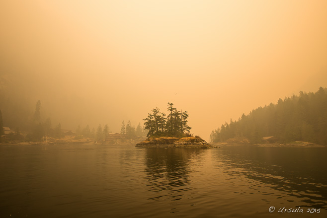
Entrance to Princess Louisa Inlet The light through the smoke from a 20,000 hectare forest fire in the Elaho Valley some 20 kilometres away casts a muddy orange hue over the entrance to Princess Louisa Inlet in BC.
“There, to your left, you can see one of British Columbia’s highest waterfalls,” our guide and boat operator Tim said – and laughed, because we couldn’t see the cliffs rising either side of us, or the waters falling from the tops, or indeed, anything more than four feet away.
Forest fires are raging across British Columbia in Western Canada at the moment. While this is not uncommon in the province’s Interior, the coastal regions – with their maritime climate and frequent rains – are much less used to uncontrollable burns. But, there was less than usual snowfall in the coastal mountains last winter, higher than normal spring temperatures, and less than expected precipitation. So, the extensive forests are dry in the extreme.
Last Saturday (July 4th 2015) when we entered the north side of the Sechelt Peninsula, the day was sunny and hot and the skies were brilliantly blue and clear. Sunday morning, however, the air over Sechelt was full of smoke from the Old Sechelt Mine fire, one firefighter was dead, and a number of homes were on evacuation alert.
We were well out of the danger zones, and thought we’d be fine the next day – an hour’s drive and a two hour boat trip away – in the Princess Louisa Inlet. I checked with the operator of the tour we planned to take: “Will the visibility be ok?” I asked. “No problem!” she assured me.
I guess it is all relative.
Reputed internationally as an area of stunning beauty, the 6 kilometre (3.7 mi) inlet is preserved as a Provincial Marine Park for its unique ecological system. Sheer granite walls, carved out by glaciers millennia ago, rise more than 2,100 metres (7,000 feet) above the still waters in the Pacific coast’s only true fjords.
Of course, with the dense smoke from the uncontrolled 20,000 hectare forest fire in the Elaho Valley, some 20 kilometres away in the Coast Mountains northwest of Whistler, we could see very little of the magnificent scenery we knew to be around us.
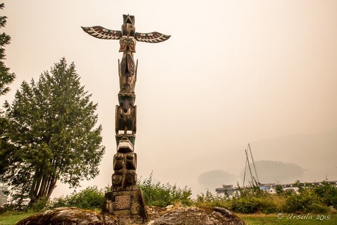
Welcome Totem Pole When we arrive at the Back Eddie Pub in Egmont – the starting point of our tour – we can hardly see the islands across the small harbour.
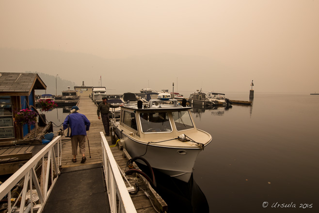
Tour Boat Smoke hangs in the air and ash falls like snow as passengers make their way to the Sunshine Coast Tourboat, which will take us the roughly 90 km north to the entrance to the Princess Louisa Inlet.
Our Guide Tim Our guide gives us a detailed commentary – when he is not sounding the fog horn and trying to steer through the obscurity.
Private Island Many of the islands around Egmont are privately owned. This one is said to be the small town’s “biggest employer”, as maintenance staff work year round.
The Waters The waters of Jervis Inlet spread out behind us as we speed north.
The Woods around Jervis Inlet The sun is red overhead, casting an orange glow as it tries to illuminate the inlet through the smoke and ash. We can only just distinguish the trees on the rocky shoreline.
Soda Creek Waterfall Our first stop is to admire a waterfall pounding down from the glacier in the mountains above. Young men of the Sechelt Indian Band used to prove their fortitude by standing in the glacial waters on the ledge at the base of the falls. They then demonstrated their bravery by diving from the top.
Petroglyph The first petroglyph we stop to look at, just before Vancouver Bay, is thought to be up to 4000 years old. It is believed the picture was last “touched up” about 300 years ago.
Granite and Iron Foreshore Even through the smoke, we can see the coloured striations of the rocky shores of Jervis Inlet.
Petroglyph Our second petroglyph is high on a rocky ledge, and hard to see through the smoky air.
Bald Eagle High in the ashy trees, a bald eagle keeps watch; its partner is surely nearby.
“Beyond Malibu” These waters off the British Columbia coast have long been visited by colourful characters. Herman Caspar, who was a squatter with no legal rights to the property, sold the land at the entrance to the Princess Louisa Inlet to American aviation executive Thomas F. Hamilton for $500 in 1940. Hamilton wanted to build luxury resorts for visiting yachtsmen and Hollywood celebrities. Unfortunately, his grand plans came to little when someone contracted polio in in 1950, and the resort was abandoned by panicked staff and customers alike. In 1953, the property was bough by Young Life, Presbyterian Minister Jim Rayburn’s organisation, and it has run as a Christian summer camp for teenagers ever since.
Seals Only the eyes of the local harbour seals can be seen through the water and haze.
Princess Louisa Marine Provincial Park The pathway into the woods is a welcome respite from the smoky air.
“Laird of the Inlet” Another priceless character, James F. “Mac” MacDonald (1889-1978), bought 45 acres (18 ha) of wilderness in 1919. Rather than profit from its sale, he set up the Princess Louisa International Society and donated the lands to it in 1953. Since 1964, the area has been managed jointly by the Society and BC Parks. The moss and lichen surrounding the plaque in the park is crisp and brown from heat and lack of water.
Picnic Hut This hut is dedicated to James F. “Mac” MacDonald, the originator of the park. When he built his first cabin in the here, “Capi” (M. Wylie Blanchet) had already been visiting the area with her five children for some years.
Moss and Flowers Inside the forest, it is still hot and buzzing with mosquitos, but there are ample rewards.
Loquilts River Waters Mossy rocks and logs divert the Loquilts River waters at the base of the famous Chatterbox Falls.
Chatterbox Falls Because of the smoke and haze, I found the best view of the famous Chatterbox Falls was from far below. One day, I will get back in good weather, and take the classic “full frontal” shot that adorns all the literature!
Malibu Rapids Many boats can only cross the Malibu Rapids at slack tide. Although the narrow stretch of water is short, it is fast moving (approximately 9 kn or 17 km/h) and creates eddies and whirlpools that are dangerous to small craft.
Another Waterfall Turning into Queen’s Reach, we pass another waterfall, and a private boat dock for Beyond Malibu.
Rocky Coast As we return to base, we sometimes imagine the smoke has lifted – but I suspect we have just got rather used to it.
Seals on “No Tree Island” On what was once “One Tree Island”, the seals pile up on the seaweed at the waterline.
Jellyfish Back at our boat dock, we observe the jellyfish…
Great blue heron (Ardea herodias) … while a heron watches the harbour.
Editing my raw pimages was a challenge: all my pictures looked as if they had been run through a sepia filter. I suppose the new Lightroom CC would de-haze all my photos, but would that then accurately represent the day we had experienced?
We had some discussion, when we arrived home, about whether or not we should have been expected to go on the tour, given the dangerous air quality and low visibility.
But, on the other hand, that is the nature of Nature.
She is unpredictable. And we need to appreciate all her colours –
The Waters The little town of Aigle at the foot of the Swiss Alps is known for its white wine – and its many water fountains.
“Good morning,” said the little prince.
“Good morning,” said the merchant.
This was a merchant who sold pills that had been invented to quench thirst. You need only swallow one pill a week, and you would feel no need of anything to drink.
“Why are you selling those?” asked the little prince.
“Because they save a tremendous amount of time,” said the merchant. “Computations have been made by experts. With these pills, you save fifty-three minutes in every week.”
“And what do I do with those fifty-three minutes?”
“Anything you like . . .”
“As for me,” said the little prince to himself, “if I had fifty-three minutes to spend as I liked, I should walk at my leisure toward a spring of fresh water.”
― Antoine de Saint-Exupéry, The Little Prince
I agree with The Little Prince: there are few things more refreshing than a spring or fountain of fresh, artesian water.
Aigle, a town of fewer than 10,000 people in Vaud, Switzerland, on the east edge of the RhôneValley at the foot of the Swiss Alps, has recognised the value of its many old water fountains which still flow freely with fresh, clean water. The local Department of Tourism has designed a 5 kilometre walk which takes in 27 of the 40 fountains scattered around the little town.
In Every Town a Castle! As we come down the mountains into Aigle, we look over the old castle, a site of Swiss national heritage significance, which sits amid the vines and green fields (iPhone 5).
L’Aigle The town’s namesake, L’Aigle (The Eagle), sits proudly atop Fountain #22, sculpted in 1940.
Church The narrow strrets are lined with trees and old buildings.
Fontaine du Carroz The notes on this fountain, the Fontaine du Carroz, remark on the irony of having the “most decorated” fountain ajoining the house of the town’s principle protestant reformer, Guillaum Farel.
Old House
Place du Marché Wine – especially white wine – is central to this region’s identity.
Town Centre
Fontaine Rue Colomb
Fontaine Rue Colomb Everywhere there are fresh, cool waters and a tumble of flowering plants.
Bottle in the Traffic Circle The wine theme is repeated in the large fountain in the traffic circle leading out of town.
Rouelle du Grenier (Jérusalem) This large, somewhat austere, fountain was built in honour of legendary William Tell (Guillaume Tell).
Rouelle du Grenier (Jérusalem) The water flows continuously – a concept I find amazing after too many years of liveing with water restrictions in arid climates!
Place Alphonse Mex Named for a locally famous personage, Place Alphonse Mex is home to a large, fanciful pond.
“Follow the Waters” We follow the trail markers …
The Waters Around … across the fast-flowing canal ..,
The Vines Around … to the tidy vineyards and estates surrounding the town. Aigle wineries comprise 132 hectares of prime growing region.
The Waters and Vines Around Everywhere, the flowers decorate the fountains against a backdrop of mountains and chaming farmhouses.
Fountain #4 Many of the spigots are elegant in their simplicity.
Rue du Rhône
Quai de la Gare (iPhone 5) Ironically, Fountain #1, at the train station was the last one we saw…
Quai de la Gare (iPhone 5) … as we had somehow missed it when we first arrived into town.
Mountain Rails The cog-train is waiting to take us back up into the mountains…
Leysin … to the even smaller town of Leysin where we were staying.
I hope, like the Little Prince, to always have the time for a walk to a spring, or a well, or a fountain.
[…] Leysin, a village at 1263 metres in the Vaud Alps, high above Aigle in the Rhone Valley (q.v.: A Walk through the Waters), home to international schools and a sports academy, and reputed to be a year-round holiday […]ReplyCancel
[…] making extensive use of them to get around the country (eg: Wanderweg around the Pfäffikersee; Balade Des Fontaines, Aigle; Château de Chillon; Schaffhausen and Neuhausen am Rheinfall; Gruyères; The Salt Mines of Bex; […]ReplyCancel
“Mothers of India” There is something very Indianabout women and children joyfully running to music, up and down a border road with a huge flag flapping, while soldiers watch over them.
It has to be one of the most unusual and amusing “ritual” displays I have ever seen!
Every day before sunset, thousands of Indians and a smattering of foreign tourists pour into the Indian BSF (Border Security Force) region at the Attari-Wagah joint check post (JCP) to watch the ceremonial lowering of the Indian flag.
We – a group of travel-photographers under the guidance of photographer Karl Grobl and local guide DV – were told exactly where we could sit, and were reminded that – although the dancing, races, and displays of mock-military prowess were all in good humour – the assault rifles that the military guard carried were deadly real. We were to remain in our seats and do as we were told at all times.
Duly noted!
JCP Attari Border “Activities Carried out at JCP Attari [include:] 1. Daily Retreat ceremony.” That is what we have come to watch.
Female Border Guard They might be fully trained military personal, but they are still ready with the welcoming smiles.
Indian Border Security Force (BSF) Officer The Indian Border Security Force officers stand out in their bright red-and-gold headdresses…
BSF Officers … as they direct the crowd …
BSF Officers … into the right sections of the stands.
Indian Border Security Force (BSF) Officer A relatively modern unit, the BSF have been guarding the Indian border since 1965.
Running the Flag The first activity involves “racing” with the Indian flag, up and down the road, to loud and joyous music. Everyone is a winner!
Running the Flag Young men carry the flags into selected areas at the top of the stands…
BSF Officer … as the guards in their spats and spectacular headdresses maintain order.
Indian Flags The men in the back rows hold on tight …
Indian Flags … as the flags wave overhead.
Border Guard Fortunately, everyone knows their place, and the guards don’t need to say anything twice.
Indian Border Under the benevolent smile of Mahatma Gandhi, …
Any Excuse to Dance! … the music changes and dancing Indians fill the street.
Barbed Wire and Smiles High in the stands, other Indians watch.
Indian Border Security Force (BSF) Officer
The Other Side Although the Pakistani Rangers also conduct ceremonies on the Wagah side of the border, the mood seemed much more subdued.
Singing the Praises On the Indian side the national anthem starts, and everybody sings with gusto and pride.
STOP The gates are closed…
Old Man with a Flag … a last old man with a flag runs through, …
Forces Marching … and Sikh soldiers clear the way.
Indians and their Flags The crowd waits…
Warm-ups … as a soldier practices his high kicks…
Women Marching … and two female soldiers march in quick-time.
Women at the Gate The soldiers stand at the gate to the no-man’s-land between India and Pakistan…
Men in Step … as the men march quick-time …
Walk and Kick … and kick at their counterparts on the other side of the gate.
Marching Out Fortunately, we are not the only ones smiling and laughing as the the men perform their quick marches, high kicks, and crow cries at the “enemy” through the closed gate in displays of prowess.
High Kick … The struts and kicks continue for some time at the open gate …
… and Return … as the Pakistan Rangers (PR) stand guard on the other side.
Meanwhile on the other Side After raised fists, struts, and high kicks from both sides …
Lowering the Flags … the flags of the two countries are lowered simultaneously.
Marching the Flag In The flag, specially folded so that the blue Ashoka Chakra shows on top, is marched into the BSF building…
A Portrait of Nitin Tyagi … and it is time for us to leave …
Preet Singh … catching a few faces along the way.
Satnam Singh With all the joyful people and smiling faces, …
Barbed Wire … it is easy to forget the ongoing deadly tension between the two countries.
It was an incredible display: like matched peacocks showing off.
We were not allowed to move around, but the view at ground level is even more extraordinary, as you can see in this irreverent video I found on YouTube:
Birr Castle and Gardens Like something from a fairy tale, Caisleán Bhiorra (Birr Castle) sits, ivy- and rose-covered, amid the greenery of its expansive gardens.
Can you imagine living in a castle? A castle with roses climbing up the walls? A castle that looks like something out of a old fairy tale?
In 1620, governance of the village of Birr in County Offaly, Ireland;old Birr Castle; and 1,277 acres (5.2 km2) of land were given to Sir Laurence Parsons. Sir Laurence, grandson of one of the five Parsons brothers who moved to Ireland from England in the late 16th century, commissioned the building of a new castle.
And so it is that Birr Castle, dating back to the 1600’s, with some alterations and refurbishments, continues as the family home of William Clere Leonard Brendan Parsons, 7th Earl of Rosse (known as Brendan) – descendent of Sir Lawrence, husband, father of three, grandfather, and an Irish peer since 1979.
Much of the grounds that belonged to the castle – the “Demesne” (or domain, from the Latin dominus, “lord, master of a household”) – was originally landscaped in the 18th century by the 3rd Earl of Rosse, Sir William Parsons. Over the years, the family collected and cultivated one of the richest collections of exotic trees and shrubs to be found in one place. Today, 50 hectares (123.6 acres) of parkland, formal gardens and waterways are administered by the Birr Scientific and Heritage Foundation and are open to the public.
Irish Robin The castle’s old stable block now houses a café, a shop, and Ireland’s Historic Science Centre. As we drank our coffee outside, an Irish robin welcomed us.
Irish Finch A finch also hangs around, hoping for crumbs.
Inside Ireland’s Historic Science Centre In addition to having an interest in botany, the 3rd Earl of Rosse (1800 – 1867) was an astronomer. His wife Mary Rosse, Countess of Rosse, was a pioneering photographer, …
Perpetual Motion Machine … and Birr Castle was a centre of scientific discovery and innovation. The restored Stable Block houses an extensive collection of astronomical instruments, cameras, photographs, and photographic equipment belonging to the family in the middle and late 1800s.
Telescope Lenses Larger lenses were central to the development of larger telescopes; …
The Leviathan … and during the 1840s, Parsons was able to build the Leviathan of Parsonstown, a 72-inch (6 feet/1.83 m) telescope.
72-Inch Reflecting Telescope Until the early 20th century, the Leviathan was the world’s largest telescope by aperture size.
Telescope Machinery Lord Rosse made a number of astronomical discoveries with this (now restored) telescope.
Telescope Housing Dismantled in 1914, the telescope was restored in the 1990s with the help of Mary Rosse’ original photographs. Still in working condition, it stands against a rainy sky as a magnificent example of engineering achievement.
Bridge in the Demesne It is an enjoyable walk, meandering around the castle grounds.
Flowers in the Demesne The flowers thrive in the rainy weather.
[…] spent the morning at the ruins of a centuries-old monastery (Clonmacnoise) and a lived-in castle (Birr Castle), and we were looking for the home of the world-famous Irish whiskey, Tullamore Dew, to round […]ReplyCancel
Makam Raja Sidabutar The garden with the sarcophagi of the Kings of Sidabutar, reputedly the first people to set foot on Samosir Island in Lake Toba, North Sumatra, is an important cultural heritage site on that island.
The breadth of human culture is amazing to me: as much as there are similarities in the human condition the world over, there are also such differences in how people express themselves.
Sumatra is just one of the over-17,000 islands that make up the Indonesian archipelago; just one of the 922 permanently-populated islands. With its numerous ethnic groups speaking 52 distinct languages, this island alone represents a huge range of cultural diversity.
In North Sumatra, one of Sumatra’s ten provinces, most of the 13½ million inhabitants are Batak. Descendants of an Austronesian people who probably arrived in the region about 2,500 years ago, the Batak comprise “six (or nine – depending on whom you believe) separate groups with different (but related) languages and customs.” The most populous of these groups is the Toba Batak, centred around Lake Toba – the natural water-filled caldera of an ancient super-volcano – and on Samosir Island, the large volcanic island within the lake.
The fifth largest lake-island in the world, Samosir is a popular tourist destination, providing a glimpse into the rich cultural heritage and current lifestyle of the Toba Batak people. One traditional Toba Batak village is maintained as a museum (Huta Bolon Simanindo) and other special sites dot the island.
Ferry Boats on the Quay The small town of Tuktuk on Samosir Island is an hour-long ferry trip across the lake from Parapat where we (like most tourists) were staying.
Women doing Laundry As well as being a meeting point for the hourly ferries, Tiga Raja Harbour served as a good place to do the household laundry.
Into Tuktuk, Samosir Island The curved roof of a traditional Toba Batak house, or “rumah bolon”, comes into view as we approach the island shore.
Rubbish One of the big problems in relatively remote places like Samosir Island – especially those with high tourist numbers – is dealing with waste.
Tiny Buffalo; Huge Sea God Although the majority of Toba Batak are now Christian, representations of their traditional beliefs are built into their houses and depicted in statues and shrines all around the island.
Mexican Sunflowers (Tithonia diversifolia) The roads are bounded by wild flowering bushes as we climb into the hills of Samosir.
Roadside Grave Elaborate memorials to beloved ancestors are never far away; …
Rice Field Mausoleum … whether in a field or at the roadside, mausoleums of all ages and styles are everywhere.
Red White and Black Mausoleum One particularly large mausoleum we passed was easily two stories high, and elaborately decorated in traditional Batak designs in the symbolic colours of white (the holy spirit), red (life force), and black (magic).
Makam (Tomb of) Ompu Raja Rosuhul Sihaloho This site contains the remains of King Rosuhul (“Earthquake” – named so for his fabled ability to tame quakes) and about thirty of his descendants.
Grave of Ompu Raja Rosuhul Sihaloho The stone sarcophagus is approximately 215 years old. It is less well-cared-for than another we visited (later) because the clan became poor, and no longer had the right connections.
Rumah Bolon in Disrepair The traditional rectangular wooden homes, which housed up to five or six families, were beautifully made in their time, but many are very old and falling into ruins.
Toba Batak Houses In some villages, traditional Rumah Bolon alternate with “modern” box houses with cladding and corrugated iron roofs.
Buffalo on the Roof The traditional designs and symbols – like the buffalo which represents the power of the Chief – are beautifully maintained on some of the buildings.
Young Toba Batak Woman Still, there is a desolate air around most of the villages.
Tugu – “Monument” Whether they are tributes to ancestors and kings, or memorials of battles, monuments are everywhere.
Shop Keeper I am always ready to examine (and often buy) locally woven fabrics in intricate designs.
Ambarita Village Home Probably because of its proximity to a site of local importance, Ambarita Village felt more “alive” than many we passed.
King Siallagan’s Stone Chairs Huta Siallagan or the “Stone Chair Village” in Ambarita was built by Si Raja Laga Sialagan several hundred years ago. The chairs were where the village elders sat to discuss crimes, decide guilt, and mete out punishment.
Huta Siallagan – Killing Stone The ultimate punishment, decided in accordance with Pelebegu, a local Animist tradition, was by beating with a blunt object, then a ceremonial beheading, and finally the body was carved up for cannibalising. Punishments could only be decided on auspicious days according to the old Batak calendar.
The View from the Highlands The view today is miles away…
The View from the Highlands … from the ritual cannibalism of years past.
Market To get to the most important attraction on the island, you need to ford the market of souvenirs and clothing.
“Another Guide Another Burial Site” Visitors to the Makam Raja Sidabutar (King Sidabutar’s Tomb) are asked to wear a special sash as a mark of respect for the Sidabutar family, the ancient ruling clan around the Batak village of Tomok.
Makam Raja Sidabutar According to stories, one of the Sidabutar lineage: King Ompu Ni Ujung Barita was an elderly man when he finally arranged to marry a woman named Anting Malela Boru Sinaga. She broke the engagement by refusing to carry a ritual cup without handles on her head. King Ompu Ni Ujung Barita used black magic to make her crazy as punishment. His sarcophagus depicts him on the front and Anting Malela at the back, carrying a cup without handles on her head as a sign of the ultimate obedience.
Local Man at Makam Raja Sidabutar
Carving at Makam Raja Sidabutar The Sidabutar tomb site is well-maintained, and dotted with sarcophagi and small ritual carvings.
Hawker on the Ferry Dock At the end of a long busy day, we are back on the ferry.
Boys on the Shore Local boys race up to the ferry dock, disrobe down to their underpants…
Portrait of a Batak Swimmer … swim out to the ferry, hang onto the mooring lines, …
Waiting … and watch for the ferry passengers to throw money into the water.
Diving The boys all dive after the folded notes, …
The Race is On! … keeping us entertained until the ferry leaves…
Ferry on Lake Toba … to take us back to Parapat.
From cannibal kings and black magic to tourism and young lads staying fit chasing money in the lake waters…
- Performing the Ganga Aarti from Dasaswamedh Ghat, Varanasi
- Buddha Head from Shwedagon Pagoda, Myanmar
- Harry Clarke Window from Dingle, Ireland
- Novice Monk Shwe Yan Pyay Monastery, Myanmar
Packets of 10 for $AU50.
Or - pick any photo from my Flickr or Wanders blog photos.