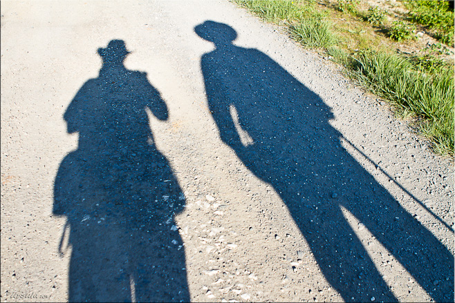
My husband and I sat in the hotel breakfast room, people-watching surreptitiously over our coffee and croissants. The only other occupant of the room was a woman in walk-pants, about my age, with a round quirky face and short curly hair. She sat in a booth opposite us, unhurriedly drinking café au lait and thumbing through a glossy magazine. Meanwhile, in the hotel lobby, a fit-looking man of about the same age, in impossibly-short shorts (of the kind only Europeans would wear), woollen socks and solid hiking boots, hoisted a large back-pack onto his shoulders and paced: alternating between coming into the dining room to talk to the woman; checking the roll of topographical maps and guide book he was carrying; and querying the elderly proprietor in the lobby as to the best routes out of town.
It was the first morning of the second half of our walk through the Cathar Castles of the Pyrenees. I have written before about the colourful characters that inhabit the region, and once again we were to find the people on the road every bit as fascinating as the area’s history and scenery. The two French-speakers we’d been watching seemed to be together, yet they were so clearly not marching to the same rhythm!
After our breakfast, we too, got instructions from the hotel proprietor and, leaving the French couple behind, set off on a shortcut to find the sentier Cathare (the Cathar trail). We strode out at a good pace, reaching Ginoles, the first of our Pyrenean villages, ahead of schedule.
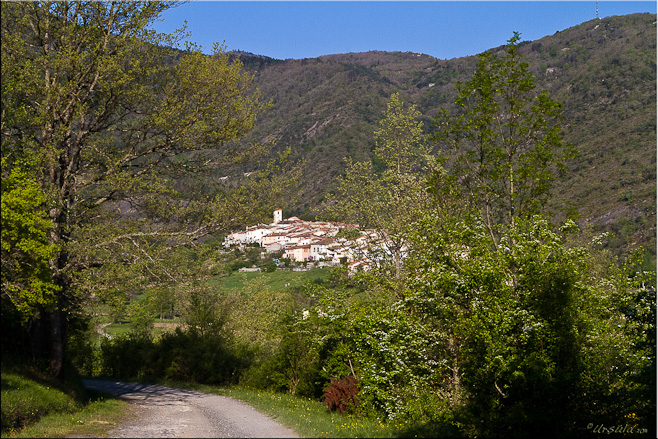
Ginoles, home to 369 people in 2007, comes into view.
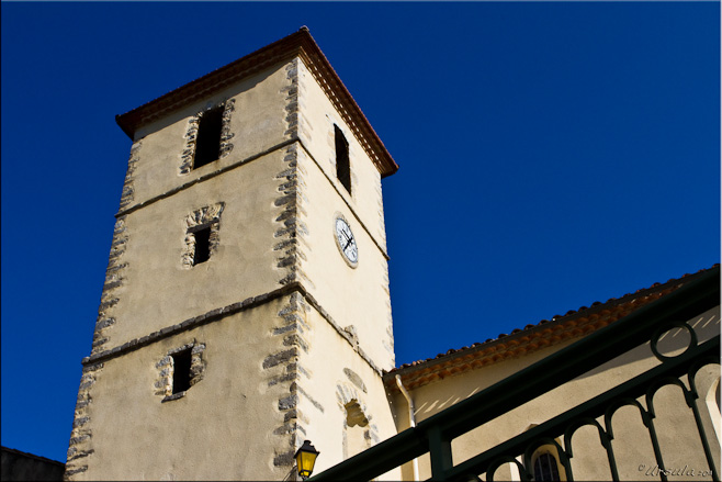
Every small village: a church.
A long, relentless climb up a shale mountain rewarded us with a view back over picturesque Ginoles.
From Ginoles, it was all up hill! Literally.
Up a coline de schiste noir, a black oil shale hill, radiating with heat and riddled with loose stones that threatened the safety of our ankles, knees and hips, we played leap-frog with the French couple: over-taking or being over-taken by one or both of them, each time with a polite “Bonjour!”, as we made our way up the seemingly endless hill before entering a pass through the forest and coming out the other side at Coudons.
Hunting hounds greeted us, back on the D613 at Coudons.
Gnomes Point the Way ~ La Fage
Mustard, Brambles, and Mountains ~ La Fage
Pine Cones ~ La Fage
Typical French Pyrenean housing ~ Nébias
It was nice when the pathway was clearly marked! Nébias (Photo by Gabe)
According to our notes, there was a restaurant at Nébias offering regional cuisine (Restaurant Le Thury, 66 Allée Promenade – no internet!). Not withstanding how good our packed picnics had been along the way, we were ridiculously excited by the prospect of eating our lunch in chairs! We sat at a plastic table outdoors in the sun, savouring our main course and salad with wine, and enjoying our coffee with desert.
Next stop: Château de Puivert on the hill in the distance. Privately owned and well maintained, this historic monument is the location for a number of movies, including The Ninth Gate – which I have seen and honestly can’t remember in SPITE of Johnny Depp’s star power!
Marguerites on the Path to Puivert
“Follow the red and white stripes!” Cathar Trail Markers
The Family Pet ~ A European Wolf ~ meets us outside the Château de Puivert
The Ruined Walls of the old Château de Puivert. The castle belonged to the Cathar Congost family when, in November 1210, it was subjected to three days of siege as part of the Albigensian Crusade.
Castle Doors ~ Newer parts of the Château de Puivert were built at the start of the 14th century.
Puivert is considered the “capitale des troubadours et de la musique médiévale” – the capital of the troubadours, the composers and performers of Occitan lyric poetry and mediaeval music from the 11th through the mid 13th century. The castle owners, in conjunction with the Puivert town museum, pay tribute to these historical figures and their instruments in the musicians’ room.
View of the small town of Puivert (497 inhabitants at last census) from the «sentier des troubadours», the walkway down from the castle.
We walked down from the castle above, following the Troubadours’ Pathway, into the town of Puivert – possibly the most picturesque and charming town we had visited in the Pyrenees – to seek out our accommodation: Le Relais des Marionnettes. Here we got to meet a whole new cast of characters.
L’Atelier des Marionnettes ~ The Marionette Workshop ~ A chaotic space, crowded with life
Our charming, articulate and rather bohemian hosts, Michel et Françoise Dubrunfaut, moved from Paris to Puivert ten years ago to follow their passion. In a chaotic workshop, crowded with fabrics, papers, paints, and clay body-parts, they create the most amazing marionettes. He moulds, carves and paints the faces and bodies, while she creates the costumes. Although many were caricatures, some were incredibly lifelike. With pride, Michel showed me his rendition of Mstislav Rostropovich, the celebrated cellist and conductor (1927-2007) as he looked, seated on his chair at the foot of the Berlin Wall playing Bach Suites, on the 11th of November 1989 when the Wall came down.
At 7:30 in the evening (the magic hour in the Pyrenees) we were downstairs in the common room, and over drinks (muscat, kir or pastisse) we met the other guests: seven other hikers from different parts of France, on various stages of their passage along the Cathar Trail. Katherine and Renaud, the couple we had been ‘meeting’ all day were from Paris. They, and two women, nurses from the Chamonix region, were walking the same direction as were were, while the other three women were walking the opposite way. Over a superb dinner of vegetable and nettle soup, rattatouille and chicken fettucini, and the best strawberry shortcake I’ve ever eaten, stories of walks across France and around the world bounced around the table (in French, of course) at a rapid rate.
Two repeated themes in the atelier, the French monsieur and the kitchen witch, bore a remarkable resemblance to their creators, Michel et Françoise Dubrunfaut – the artist and his muse.
That evening, the characters from the road danced around in my head, like marionettes on strings – each with it’s own own unique personality and story.
Take isolated communities growing rice and raising cows and chickens in rural Cambodia where few roads reach, and you have a need. Take some rail track in disrepair, a bamboo raft and a small motor and you have a solution.
Meet “The Bamboo Railway”: the ear-splitting, bone-rattling, wind-in-your-hair, bushes-in-your-face solution to transporting goods and people from Battambang to points south and back again.
The "Norry" or Bamboo Rail Car is Powered by a Small Motor
Metal Wheels on the Rail Line
Holding the whole thing together with bent metal rail ties...
The Smoking Man: Our Driver is a Cool Dude
During their colonial rule, the French put 400 miles of rail line across Cambodia, but the years of war, civil war, and general instability since they departed the country in 1953 have taken their toll. Although the Khmer Rouge were overthrown by the Vietnamese in early 1979 after a four-year reign of terror, they continued to wage guerrilla war throughout the country into the late 1990s, making the railway one of their targets. They planted land mines along the rail lines (and elsewhere, of course) and frequently ambushed trains. Conventional trains have run only irregularly for years, and passenger trains stopped completely over a year ago. Since the first rails were laid in the 1920s, ingenious locals have braved the hazards of oncoming locomotives and potential mines to use the lines to advantage.
Our trip to the railway had been organised by our able photo-tour/workshop leader Karl Grobl. We left our comfortable beds at our delightful hotel in Battambang at six am – that’s six am – and climbed into local tuk-tuks to arrive at the local ‘train station’ – a loose collection of bamboo and wooden buildings on a dusty road – in time to watch the ‘norries’, or rail-riding platforms, be put together. It’s simple really: lift two metal wheels welded to an axle wide enough to fit the rails onto the track in pairs. Rest a bamboo platform on top. Fix a small motor to the rear axle with a fan belt that passes through a hole in the bamboo, and you are set. Passenger ‘norries’ come with a cushion for comfort – if you are lucky.
All you need is a small motor, a fan-belt and a little push, and you are off!
Speed! We rattled and bumped, being whacked by bushes, at speeds of up to 50km/hour.
As rail lines weave and wobble toward the norry in the distance, goods wait at the side of the track.
Endless rice patties, Battambang Province
Apparently, you can ride bamboo trains all the way to Phnom Penh. I have no idea how far we went because none of the ‘towns’ we stopped were signposted in English, and I know they are not on my map. We bumped past countryside uninterrupted by roads, enjoying the cooling wind in the already hot, humid morning and getting a wonderful view into a world less-travelled by tourists. Everywhere we stopped, people were happy to come out to greet us, and to allow us to photograph daily life.
A kitten and her friends welcome us to some small hamlet in Battambang Province
Light ~ Dark ~ Heat : Bringing in the Rice
Washing the Morning Dishes
This woman keeps the accounts at the local rice storage shed.
Piled Passengers in a Tractor Transport
Small Town Shopkeepers
Roadside Laundry. Note the glass bottles of gasoline/petrol behind her.
Hulling the Rice Harvest
Local Barber Shop
To accommodate two-way traffic on a single line, Norry courtesy dictates that when two carriages meet, the one with the lighter load leaves the track. Drivers and passengers pitch in to disassemble and reassemble the norries to allow passage. This process was surprisingly quick.
"Incoming!" An over-loaded norry gets right of way...
The lighter load stands aside, off the tracks, to allow passage.
Tourist norries are easy to off-load, as there is nothing on them but people!
Rebuilding the norry takes only a few moments.
No whistle... No bell... The only choice is to wait until the cows wander off...
"Don't look down!"
The Bamboo Railway is technically illegal, and clearly there is no Occupational Health and Safety committee supervising its operation! There is rumour that the rail line is going to be repaired and ‘proper’ trains will run again. But, this is Cambodia, and these things take time…. Until the repairs happen, the norries and their resourceful drivers are filling a local need and bringing in tourist dollars.
Riding the Rails!
I had a wonderful morning ‘riding the rails’, but as soon as we stopped moving, the heat and humidity enveloped us like a fog. I had to keep reminding myself that it wasn’t yet 8:30am. The six am start to our day was starting to make sense, and I could only sympathise with those who had to ride the bamboo rails through the midday heat.
[…] For additional images and information about the bamboo train, you might enjoy these two other blog posts; the first from a 2010 blog post here and another from 2011 Angkor Photo Workshop participant Ursula Wall, which can be seen by clicking here. […]ReplyCancel
April of 2010, I spend a magical three days in Varanasi, India, with photographers Gavin Gough and Matt Brandon. One of the ‘homework’ tasks they gave us was to make a themed Soundslides presentation.
The Hindu faithful recognise the integration of five elements: earth, air, water, fire and spirit. I was fascinated by the use of fire in the daily observances that are conducted everywhere along the Ganges River. From pre-dawn until after dark, ritual fires burn in Varanasi to pay tribute to the Mother Ganges.
Here is my depiction of the Faith Fires in Varanasi.
I’m in Cambodia at the moment with four gifted professional photographers and thirteen talented amateurs. All I can say is this: Thank heavens I’m not taking pictures for my living! It’s not that my photos are bad – well, not all of them – it is just that those taken by everyone else are extraordinary.
Khmer Gods line the right side of the bridge to South Gate, Angkor Thom, 12C
Our photographic mentors and tour leaders, Karl Grobl, Gavin Gough, Marco Ryan and Matt Brandon have kept us busy chasing light in what can only be described as an aspiring photographer’s paradise: gentle, smiling, photography-friendly people, impossibly green landscapes, and the mystical, magical ruins spanning 400 years of Khmer civilisation. Week one of our trip, which we spent in and around the temples of Angkor, culminated in a program of slides showcasing everyone’s photo-stories. The themes of the stories demonstrated the breath of our group: there were stories about temples, about people’s lives, about tattoos, about the arts, about tuk-tuks and their drivers, etc. Mine was on schooling and education (no surprise to anyone who knows me) and I’ll probably share bits of that in weeks to come.
Our schedule has been gruelling, as we have alternated between the classroom and location shoots. Any free time I’ve had has been spent trying to come to grips with new technologies, which are always two or more steps ahead of me, and dealing with temperamental computer systems, which have been threatening to fail. So, I’m running… I guess I’ll process it all (photographically and metaphorically) when I return home next week.
In the mean time, I’ll share some of the faces of Bayon and the South Gate, Angkor Thom.
Gods on the Right... South Gate, Angkor Thom, 12C
Demons on the left... South Gate, Angkor Thom, 12C
Workers in the middle... South Gate, Angkor Thom
Golden Pheasant Long Boats, Angkor Thom Moat
The Bayon-style (1181-1243) South Gate stands twenty-three meters high. The faces look out over King Jayavarman VIIs domain in all four directions. Angkor Thom.
We visited the Bayon temple in Angkor Thom on two separate occasions, and I never tire of it. My problem is deciding which of the almost-exactly-the-same pictures to select and keep!
Paying tribute to a pantheon of gods from Hinduism and early Buddhism, the Bayon was built in the early 1200's. Thirty-seven of the original fourty-nine (or fifty-four?) Bayon towers are still standing.
In the Bayon, you are surrounded by the enigmatic smiles of the Bodhisattva of Universal Compassion. No one is sure exactly how many faces there are!
The smiles of the temple workers are just as warming.
Lighting the Temple Fires
Candle Light and Incense Burning
One of several Buddhist shrines hidden in Bayon's maze.
Buddha's Blessings
Student Worker, Bayon
More Smiles: Beetle-nut Granny and Bodhisattva
Avalokiteshvara Bodhisattva, the Mahayana Buddhist ideal of Compassion
Last smile of the Avalokiteshvara Bodhisattva 'Lokesvara' for today...
Entry to the temples is free to Cambodians and it is nice to see families enjoying their heritage.
Tuk-tuk drivers rest until their customers return from the temples
Until next time, may you keep smiling and may the Bodhisattva smile on you.
Ursula, you’re absolutely correct. Never get tired of the photo’s. I especilly like the photo of the keeper of the light, the laughing elderly lady and the two boys at the end. The perspective behind them is cool. Way to go.ReplyCancel
I have come to love my Friday morning trips to unknown places, well unknown to me that is. What a wonderful way to start my day, enjoying the wonderful photo’s and the magic descriptions. I am blessed, thank you.ReplyCancel
Ursula -July 21, 2011 - 11:58 pm
Heartfelt thanks to my two most vocal readers! I’m so happy to have you both along. 🙂ReplyCancel
“Try to focus on one thing – it could be one colour, one idea, any one thing, really,” instructed our photo-tour guide Gavin Gough. “Don’t just wander around taking pictures of everything!”
Young Thai Eating Breakfast, Yaowarat
Now, I have enormous respect for Gavin, Bangkok-based travel photographer and teacher extraordinaire, but I was about to head into Yaowarat, Bangkok’s Chinatown, for the morning with a small group of other aspiring photographers. Trying to follow the advice to ‘focus’ in this richly textured neigbourhood, seemed an impossible task! For me, being in Chinatown with a camera is a bit like being a kid in a candy store. The environment is a sensory feast: chaotic colours are piled on top of each other in narrow shops and in bins on any available pavement; the heat and humidity are pervasive, accentuating the humming energy and the somewhat claustrophobic atmosphere; the noise of machinery combines with chatter and barter in several languages; shoppers jostle with tourists, giving way to motorcycles and coolies with over-laden trolleys. Ido feel the impulse to photograph everything!
Luckily for me, the first exercise Gavin gave us was to shoot some black and white frames with a wide angle to try to draw attention to one thing. This exercise quieted my humming senses, and my target for the day came to the forefront: I decided that that I would focus on the people .
So, here are a few of the people of Bangkok’s Chinatown, going about their daily business.
Motorcycle taxi drivers in their candy colours wait for customers.
A labourer at the peanut- and rice-seller's shop takes five.
Proud owner surveying his domain ~ He offered us delicious samples of his peanuts, rice and fruit.
Break time is over ~ and the labourer is back to work moving peanuts.
Smiling while he works: another labourer moving more peanuts.
Three children of local shop-keepers pause from their colouring to give me big smiles.
In the Madding Crowd ~ People Everywhere!
An enormous Lady Luck welcomes you into the area.
It might be early morning, but some workers have had long nights!
It's hard to stay engaged when you have no customers!
A matriarch keeps an eye on proceedings.
Cleaning fresh fish for sale, Yaowarat
Scaling the fish, Yaowarat
Bagging Loquat (Japanese medlar, Nispero) for desserts.
I asked this woman selling chicken feet how long she'd been working in the markets... I didn't want to do the impolite thing and ask her age!
Sixty years, she told me. She started work as a young girl, bagging spices.
A young man looks out between the birds at the Chinese duck noodle shop
Having reached the end of Chinatown, we climbed in a tuk tuk for the short ride back to the pier.
The Sun has Set, Wat Arun, Bangkok
Later that evening as we had drinks watching the darkness descend over Wat Arun, I couldn’t help but think about the variety of people, activities and occupations in that one small area in Yaowarat. Our daily lives are all so different, but with a little bit of work, they can all fit together.
Where ever you are, whatever you are doing, happy travels!
Love this series, some really tremendous environmental portraits. I have booked a few nights at a hotel in Chinatown, as each time I visit it never seems long enough.ReplyCancel
Ursula -July 15, 2011 - 11:46 am
Hi Guava! Thanks so much for your comments. Chinatown is, indeed a feast!ReplyCancel
Perhaps it’s me but two things stand out in these pictures, the older women who are so poised and the smiles. A quick walk around Liverpool wouldn’t bring such a thought of joy as you work, yet these hard working humble people seem to make the most and best of everything they do, which is something to be admired. Thank as always for sharing your travels, love it!ReplyCancel
Ursula -July 15, 2011 - 2:04 pm
Too right, Signe! People work long and hard, often under uncomfortable and/or unsafe conditions – and usually with a smile and good humour!ReplyCancel
gabe -July 14, 2011 - 11:35 pm
Lovely work sweetie. Love the smiles even after ten years in Bangkok they always seem genuine.ReplyCancel
[…] and a wander into the always-photogenic Chinatown, better known locally as Yaowarat (see: A Day in the Life). Our aim was to find Wat Chakkrawadrajawas Woramahavihara, which neither of us had […]ReplyCancel
- Performing the Ganga Aarti from Dasaswamedh Ghat, Varanasi
- Buddha Head from Shwedagon Pagoda, Myanmar
- Harry Clarke Window from Dingle, Ireland
- Novice Monk Shwe Yan Pyay Monastery, Myanmar
Packets of 10 for $AU50.
Or - pick any photo from my Flickr or Wanders blog photos.


 Until next time, stay cool and travel safe!


 Later that evening as we had drinks watching the darkness descend over Wat Arun, I couldn’t help but think about the variety of people, activities and occupations in that one small area in Yaowarat. Our daily lives are all so different, but with a little bit of work, they can all fit together.


Yes is was a good day, difficult but as you said, we met a large range of individuals. Good weather and experience.
Magic!
Cheers! 😀
Hi Ursula – nice blog and useful as I plan to do this walk (the other way) along with three friends. Thank you. Jim
Hi Jim,
I glad you enjoyed the posts! It is a great walk and I’m sure you will enjoy it.
Bonne chance!