Summer in Australia’s “high country” is known for it’s clean crisp air, abundant wild flowers and various outdoor activities; it is possibly less well know for its music. But, during ski season there are plenty of live acts in the various pubs and chalets, and summers bring various festivals, including an Irish Cultural Festival and a Jazz Party.
“Personal venues” can be translated as small restaurants not designed for live music, making it imperative to book dinners early if you want a view of the performers unobstructed by walls, pillars or other diners. I don’t have enough of an “ear” to comment on the sound quality in these venues, but certainly found the chattering of other patrons annoying some times – and downright disruptive at others.
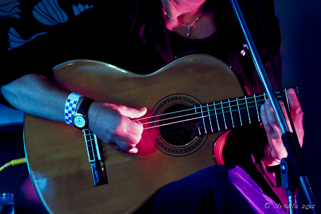
On the first evening, we stopped in for sets at a pub and a lounge before heading off to dinner at The Knickerbocker for what proved to be one of the highlights of our weekend in terms of food and service, and with respect to the entertainment: Hat Fitz and Cara Robinson.
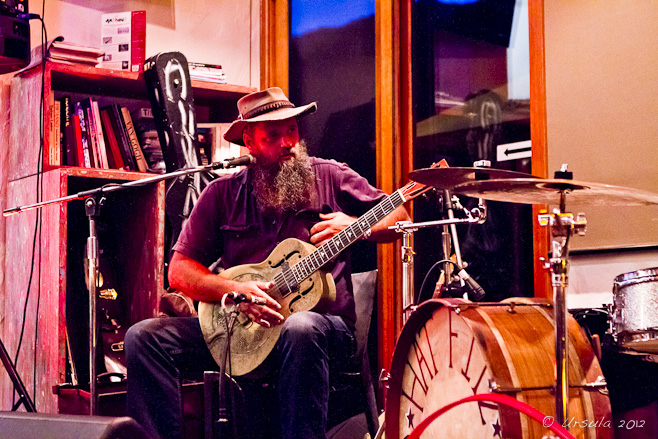
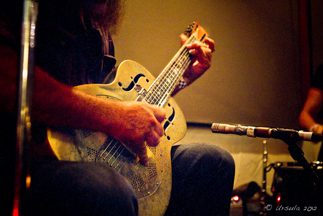
Hat Fitz, the epitome of pre-war hill-country and delta blues, on his steel guitar.
Hat’s National Steel Guitar
I saw Hat Fitz perform many years ago at the Byron Bay Blues and Roots Festival, and thoroughly enjoyed his show. The addition of Cara Robinson, multi-instumentalist and powerhouse singer from Ireland, turns his already-good performance into magic. There were a couple of times we had goosebumps as Cara’s voice ranged freely across the scale and held notes effortlessly.
(You can click or double-click the audio link below for a studio version of their performance of Wiley Ways.)
Hat Fitz on guitar with Cara Robinson on percussion.
Cara Robinson on one of her wind instruments.
When Irish eyes are smiling…
Robert Susz, a ubiquitous presence on the live Australian music scene, pops in to play harmonica.
We knew it would be a hard act to follow, so while the different versions of the blues continued in pubs around Thredbo Village, we toddled home to our lodgings for a fresh start at the outdoor performances the next day.
Marco Goldsmith fronts the seven-piece rhythm & blues Blue Heat.
Robert Susz and Dave Brewer from the Mighty Reapers
Robert Susz on his harmonica.
Clayton Doley plays keyboard for the Mighty Reapers
Clayton Doley on keyboard and Vito Portolesi on bass for the Mighty Reapers.
Many hats in the audience.
Performing jazz, blues and boogie-woogie, the “Wild Women” Lisa Otey and Diane van Deurzen in the sunny Village Square.
The Kevin Borich Band rocks out.
It’s still Rock and Roll: Kevin and his National Steel
Cooling off ~ Hat Fitz hatless
Virtuoso Australian guitarist Jeff Lang
Shiny bits: Jeff Lang’s 1960s Black Airline
More Hats in the Audience
Sound Check
The staff race to put up umbrellas…
… but the rains over-take us – as they do at all good music festivals!
Inside the Black Bear with Steve Grieve …
… and Jo Jo Smith.
When the rains came, we ducked into The Black Bear for an early dinner, and rode out the evening on the songs of Jo Jo Smith accompanied by Steve Grieve, before returning home humming and smiling.
sounds like you had a great time… I never realised there was a Blues festival in the mountains, I knew about the Presley weekend in Parkes. I do wish they would publicize this stuff more widely. Back home and you sure know how to find the good stuff not just whilst travelling.. cudo’s!ReplyCancel
[…] for an excuse (as though one is needed!) to head into Kosciuszko National Park, and we enjoyed the Blues Festival there greatly in January, so we decided to try it out. I’m not about to wade into the […]ReplyCancel
[…] decided to ease in with something familiar, Hat Fitz and Cara whom we last saw perform at the Thredbo Blues Festival in 2012. In spite of Cara still wearing an eye-patch following a car accident last December, their […]ReplyCancel
[…] was our third visit to the Thredbo Blues (e.g., The Blues in Colour). I always have one or two acts on my “must see” list, but mostly I love the laid-back […]ReplyCancel
[…] was our third visit to the Thredbo Blues (e.g., The Blues in Colour). I always have one or two acts on my “must see” list, but mostly I love the laid-back […]ReplyCancel
Australia, when it is not being buffetted by typhoons, razed by bushfires, innundated by floods or ravaged by droughts, is blessed with a wonderful climate where sunny clear-blue skies predominate even in winter: truly a Lucky Country.
A couple of years ago, in preparation for our re-patriation from Asia, we bought a small house on the southeastern coast of Australia – our little patch of the Lucky Country – where we intend to retire.
The town is aptly named Eden.
Almost surounded by the eponymous Twofold Bay, this working fishing village and popular holiday resort boasts a safe deepwater habour for recreational and working boats at its heart, beautiful swimming and surf beaches within its boundaries and National Parks all around. It truly is a little paradise!
More about all of that some other time.
Our neighbourhood sits on an estuary, a salt-water inlet, where we can join others in walking running or cycling on the elevated Allan Gibson boardwalk, running through the tea trees. This is our little slice of paradise.
Morning mists on Lake Curolo (05 Nov 2011)
Rainbow Lorikeet over the Estuary (04 Oct 2011)
Little Pied Cormorants (02 Jan 2010)
Black Swans and Cygnets (04 Jan 2012)
White Faced Heron (02 Jan 2012)
It will take us some time to be able to identify the bird- and plant-life along the boardwalk; every time we run or walk along it there are different lights and colours.
Orange Flowers against the Tea Trees (02 Jan 2012)
White bottle-brush (06 Nov 2011)
The boardwalk runs beside the estuary (Lake Curalo) and into the tea trees. (09Nov2011)
Blue Fairy Wren (female) on a Guard Rail: Allan Gibson Boardwalk (02 Jan 2010)
Of course, we are not the only ones using the boardwalk, which links the estuary to a sporting ground, a camping site and the beach, and even when there are no people in view, they are in evidence. Weekends and holidays, it is busy with people cycling, running, fishing, walking or just sitting reading.
Boat on the Estuary (09 Nov 2011)
Lone runner on the boardwalk (06 Nov 2011)
Grasses in Lake Curalo (06 Nov 2011)
There is always a mixture of life on the boardwalk. (02 Jan 2012)
Fishing in Lake Curalo (31 Dec 2011)
Black Swans at Nightfall (05 Nov 2011)
Although we have moved in, it will probably be some time before we really “retire”. Still, when it is so nice being at home, we might travel a little less.
Thanks, Susan! Not exactly the Matterhorn, but we like it. 😉ReplyCancel
Judy Phillips -March 16, 2012 - 11:54 pm
I met you briefly at Coolem Q/land last September, we know Gabe through business and he gave me your card. I am thoroughly enjoying your photo’s and seeing your love of nature and travel expressed with joy through your photo’s. Keep up the great work.ReplyCancel
[…] am also a bit lazy, and aside from regular morning walks on my boardwalk (See: A Little Slice of Paradise), I tend to not explore my neighbourhood as much as I should. So, I’m always glad when […]ReplyCancel
OK, so tarantulas are arachnids, not "bugs", but there were bugs too, as you'll see later. 🙂
A “highlight” for tourists and travellers along Cambodia’s National Highway 6 between Phnom Penh and Siem Reap is the small town of Skuon, 75 kilometres north of the capital, where spiders – fresh and fried – are a specialty.
We, however, were going the other way – from Siem Reap south to Phnom Penh – so my fellow photo-travellers and I, under the tutelage of Karl Grobl, Gavin Gough and Marco Ryan, had all morning in our personal bus to anticipate our spider treats.
Our bus ride on the death-defying single-lane highway, which runs alongside barren fields with land-mine warning signs and gloriously green rice patties, was punctuated by stops. The first stop was at Spean Preah Toeus, the largest and most important of the 11 bridges remaining from the ancient Angkor Empire period. With 21 arches spanning the 86 meters across the Chhikreng River, this 12th Century laterite and sandstone structure (reinforced with modern concrete in the 1960’s) is a major part of an arterial network, and an excuse for a few shops and houses either end.
Spean Preah Toeus (Spean Kompong Kdey)
A Pause from Work: Spean Preah Toeus
A bright, unselfconscious smile lights up the face of a Khmer lad.
Solemn Faces: Girl and Grandpa at Home, Spean Preah Toeus
Old man at home in his "sampot samloy" ("pa kao mah" in Thailand), the woven cotton sarong worn everywhere in Asia.
General Store on the Main Road, Spean Preah Toeus
Modern traffic on the dirt surface of the ancient Spean Preah Toeus, Cambodia
Local Pony Express Transport Service: Spean Preah Toeus
The Pony Express Moving Men.
Our next stop was at the market in Kampong Thom.
I love the colour of local markets, but I find them challenging to shoot. This one was no exception; a roughly built wooden frame supporting a corrugated iron roof provided shade from the relentless afternoon sun bouncing off every surface outside, but made for a dark, stifling, hot and airless interior with blinding back-lights from the outdoors. The people were mostly very accommodating, but there were seventeen of us visitors in an already overly crowded space.
So, under-expose like mad and hope for the best!
Smiles for the camera! These vendors know there is little likelihood of making a sale from this busload of foreigners, but they are happy to be photographed anyway.
Chillin' with the Community
Timeless grace ~ Elderly Khmer Woman
Whenever I see water lilies in the markets, I think of the poignant multi-media piece put together by two of my colleagues. (It can be found at: https://www.jennykrasner.com/2011/10/blog/)
I haven't been keeping up with the latest Lightroom changes, so I spent a little time playing around with the new "curves". I rather like the effect of this over-coloured treatment of a woman making waffles on cast-iron forms in an open fire.
The waffles were pretty good, too!
Sad-faced khmer girl outside the Kampong Thom market.
Our last, much anticipated stop before reaching our Phnom Penh accommodation, was the small town of Skoun (or Skun), where people breed the high-protein local tarantula species (Haplopelma albostriatum) that is a popular delicacy. The street-side market at the junction of two highways also sells a variety of edible insects, as well as fruit and vegetables.
Tarantulas for sale! Skuon
"One man's meat is another man's poison." Delicacy? To me, they just look hairy and horrible!
More local treats: spicy fried cicadas.
Yummy! Battered crickets.
"Sexy Bitch" with an innocent smile.
Beautiful young woman ~ few opportunities.
No need to stress... Saleslady and her mangosteen, pomelo and pineapples.
The tarantulas on sale here have been called “edible spider” in Khmer for more than a hundred years. Although it has been suggested that they became more popular during the Khmer Rouge years when other foods were scarce, fried insects are also popular in Thailand (see “Buddhas, Bugs and the Burmese Border”) and other parts of Asia.
Ursula, this is a wonderful post… the photos are fantastic and they bring back such vivid memories of the trip down National Highway 6. You really captured the essence of that day and obviously,you also did quite a bit of research about the area, and about Cambodian culture and thus, you have provided me and all your viewers a “complete package”. Bravo on another amazing blog post! I can’t wait to see what you come up with next! All the best, KarlReplyCancel
WOW, great share as always, I’m with you on the waffles and the spiders, I respect them and try not to kill them but eat them NEVER….stir fried or battered no bugs for me thanksReplyCancel
Thanks for joining me, Signe. None of our group tried any of the six- or eight-legged treats. I have had to eat ant eggs once, to be polite, in Thailand – and of course, green ants in Northern Queensland, but I sure don’t make a habit of it!ReplyCancel
[…] the stalls, the faces of the people, the goods on sale. While some feature edible insects (e.g. Morning Markets and Bugs for Lunch, Cambodia), others specialise in flowers (e.g. Pyin Oo Lwin Flower Markets, Myanmar; Fragrant Flowers […]ReplyCancel
Buddha on a Hill, Sai Yok, Kanchanaburi Province, Thailand
I love the concept of a “new year”.
I always have. As I said this time last year, I like to regard the period between New Year’s Day and my birthday, which follows closely after, as a time of quiet contemplation – to look back over the accomplishments (or otherwise) of the year before, and make some decisions about directions and priorities for the year ahead.
This coming year is the year of the water dragon in Chinese astrology and “will be marked by excitement, unpredictability, exhilaration and intensity.” With predictions of Armageddon by some religious groups (12/12/2012), and with Nostradamus purportedly predicting the end of the world on a date which coincides with the end of the Mayan Calendar (21/12/2012), many people are watching global natural disasters and political unrest with pessimistic interest.
For my husband and myself, this New Year marks the move from Bangkok, an Asian city of between 12 and 16 million people, to a small Australian coastal town of just over 3000. It also marks our shift from busy paid employment to slightly less-busy, mostly-unpaid employment.
The coming year will also see small changes in my “Wanders”. We will still be “globe-trotting” for work and family commitments – and for fun and photography – and we already have plans in six countries. But we will be exploring Australia, especially our own corner of it, a bit more. I may even get back to the archives and relive some “previously unpublished trips”.
The Buddha's Appeal for Peace
So, watch this space.
In the meantime, we will spend New Year’s eve and day unpacking: we’re surrounded by boxes and furniture from two separate locations piled into a house that is smaller than either.
But, we will always take time to count our blessings.
The photos here comprise a portrait of a Buddha on a hill in the middle of small roads and jungle in the Western reaches of Thailand. It was around this time last year that we were driving past it daily from our hotel on the River Kwai Noi as we played hosts to relatives from overseas. One of our guests asked if we could stop and see the Buddha up close; it hadn’t occurred to me to visit it because, living in Thailand, I had become so accustomed to buddhas on every hill!
Golden Hand of a Large Standing Buddha
Looking up to a Golden Gautama Buddha Image
Buddha's Back
Buddha's Blessings for a Happy New Year
As Buddha images go, it was a nice one. And it provides us with a timely reminder to stop and smell the flowers – and to pay respects to the Buddhas – especially in these “unpredictable” times.
Now I need to get back to unpacking; if the world is to descend into chaos, I want a orderly house!
Wishing you peace and happiness in the coming year.
seems to me boxes will be the order of the day for at least the next few. Have a great time, and may 2012 be all you’ve ever hoped for.. much loveReplyCancel
[…] This time last year we were barely into our current home, surrounded by boxes and chaos. In the intervening twelve months, we’ve managed to carve out some order and to adjust to a different kind of lifestyle in a vastly different environment. But we have also been “on the road” and away from our house for at least half that time. […]ReplyCancel
I’ve had a bit of trouble getting into the Christmas spirit this year – which is surprising, really, considering we spent last year in a country that doesn’t officially celebrate Christmas. But, even though December 25th is a normal working day in Thailand, the country goes all out to decorate for the season. Aside from a rather tacky Nativity scene at our local shopping centre, the neighbourhood around our (temporary) home in Sydney is, by contrast, remarkably clear of any seasonal decorations.
I thought it would be good to go in search of some Christmas cheer.
So, we left our preoccupations with builders and boxes behind and headed downtown to the bright lights and tinsel. Maybe it is the rising cost of electricity or a new environmental awareness, but we didn’t find any! Darling Harbour in Sydney sported several blow-up santas as part of it’s Santa Fest and a LED Christmas tree made from recycled materials, but not much that sparkled in daylight.
Santa is Watching!
Reflecting on an Aussie Christmas.
Recycled Tree
“Not particularly inspiring!” I thought.
Part of my problem, I think, is that we are still a bit dislocated (more than usual), and I haven’t been able to spend time doing the sorts of things I usually do this time of year in preparation for time with the family. The weather was unseasonal cool and overcast, and for a while it was hard to reclaim the spirit of the season.
But, Sydney is a lucky city in The Lucky Country. It could be argued that it should be Christmas everyday – and indeed, the joy of childhood and the beauty of the harbour are always around us.
Joy! Running on Water
The Sydney Olympic spirit lives on.
CBD Reflections in the front of the Australian Maritime Museum.
Cruise Boat, saying good-bye to Sydney Harbour.
So, I wish you good tidings where ever you are, and what ever Christmas means to you.
I know I’m a couple of days late which is somewhat naughty of me, and the fact you will now be in Eden not Sydney, my suggestion that a house in Malacoff St Marrickville has outdone itself with Christmas cheer is all but too late. I like you went in search of those pretty decorated homes and found but a few, in years past Chipping Norton had the reputation of being the “place to be’ with whole streets decorated so much so they had to get approval for one way traffic to accomodate the crowds… alas as you say the cost of electricity seems to have dampened the glitter for many.
May the New Year Bring you much joy in your new home.. and I imagine a good share of unpacking 🙁 … We’re looking for a long weekend to accept your kind invitation.. I will be in touch LOL
- Performing the Ganga Aarti from Dasaswamedh Ghat, Varanasi
- Buddha Head from Shwedagon Pagoda, Myanmar
- Harry Clarke Window from Dingle, Ireland
- Novice Monk Shwe Yan Pyay Monastery, Myanmar
Packets of 10 for $AU50.
Or - pick any photo from my Flickr or Wanders blog photos.


 Although we have moved in, it will probably be some time before we really “retire”. Still, when it is so nice being at home, we might travel a little less.
.jpg)


 Me, I settled for the photos.


 As Buddha images go, it was a nice one. And it provides us with a timely reminder to stop and smell the flowers – and to pay respects to the Buddhas – especially in these “unpredictable” times.


sounds like you had a great time… I never realised there was a Blues festival in the mountains, I knew about the Presley weekend in Parkes. I do wish they would publicize this stuff more widely. Back home and you sure know how to find the good stuff not just whilst travelling.. cudo’s!
You could always join us next year – we still have a room available – first in… 😉
Cool
[…] for an excuse (as though one is needed!) to head into Kosciuszko National Park, and we enjoyed the Blues Festival there greatly in January, so we decided to try it out. I’m not about to wade into the […]
[…] decided to ease in with something familiar, Hat Fitz and Cara whom we last saw perform at the Thredbo Blues Festival in 2012. In spite of Cara still wearing an eye-patch following a car accident last December, their […]
[…] to get into Kosciuszko National Park. I’ve said it before: (Summer Blues; All that Jazz; Blues in Colour) I love music in the […]
[…] was our third visit to the Thredbo Blues (e.g., The Blues in Colour). I always have one or two acts on my “must see” list, but mostly I love the laid-back […]
[…] was our third visit to the Thredbo Blues (e.g., The Blues in Colour). I always have one or two acts on my “must see” list, but mostly I love the laid-back […]