 Like a Painting
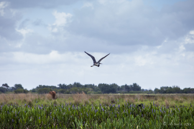
A great blue heron (ardea herodias) flies over the marshy shoreline of Lake Kissimmee. It’s a concrete-and-plastic jungle…
So much of the area around Kissimmee and Orlando in Florida is interconnecting highways, theme parks, condominiums, fast food, and tacky souvenir sales. It is pretty easy to think there is nothing else.
But, you can escape – even if only for a few hours.
It was time: we’d been in Kissimmee several days and I needed to shake off the pre-packaged kitsch. As it turns out, there are tour operators offering airboat rides not too far away. So, in spite of the rain clouds, we set off south, off the major roads, and towards Lake Kissimmee, which sits at the upper-most end of the watershed that feeds the Florida Everglades.
We’d decided on Kissimmee Swamp Tours, and – like a large percentage of TripAdvisor participants – ended up very happy with our choice. It was an hour-long drive to the office: some of it gravel, past large estates and horse studs and through brilliantly green farmlands. It felt like we had entered another world – a breath of fresh air after the neon lights, garish paint, and wall-to-wall cars on US Highway 192.
Once we were fitted into our two-way-radio headsets, we set off – just us and Mark, our operator and guide – across the lake and into the sea of grass and pond lilies.
The birdlife was fabulous! I have neither the patience nor the lenses for really good bird photography, and the constant vibration of the airboat, plus the rainy and overcast weather made for additional challenges… but I can’t resist sharing a “taste” of this marvellous place.
 The Airboat
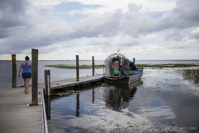
Our six-seater airboat waits to take us out over Lake Kissimmee. 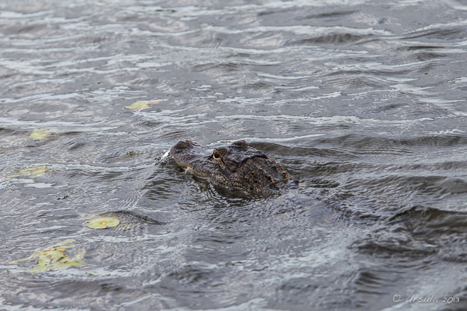 A Gator
Within minutes, we spotted our first huge American Alligator (alligator mississippiensis).  Pastoral
The red beak, face and legs of the American White Ibis (eudocimus albus) contrast markedly with the impossibly green fields. Sandhill Crane
One of a pair of two-meter cranes (grus canadensis) strides through the water hyacinth – his life-mate is not far behind. Showing Off
A great blue heron (ardea herodias) fans its wings on a grass island. Flight
A great egret (ardea alba) wings across the lake. Small Alligator
Alligators on Lake Kissimmee come in all sizes. Snail Kite – with Snail
The locally-endangered snail kite (Rostrhamus Sociabilis) is dependent on the apple snail for food. Snail Kite
The kites are tagged and tracked to monitor their numbers and movements. Snail Kite
The sharp, curved beak allows the kite to get into the snail shell. Purple Swamphen
It is the big feet that keep the swamphen (porphyrio porphyrio) from sinking. Mr and Mrs Grackle
The lake is home to numerous nesting pairs of great-tailed grackles (quiscalus mexicanus). Snakebird
The snakebird (Anhinga anhinga) is not able to oil and waterproof its wings, and needs to dry them out. Captain Mark
Our knowledgeable boat operator had studied environmental science and clearly loved the lake. Barely Visible
Even when they are not diving and holding their breath, gators are hard to spot. Incoming Squall
The pond lilies and sawgrass marshes stretch out under a threatening sky… We did get wet. Spatterdock…
… or yellow pond-lily (nuphar advena) grows all over the lake. Snowy Egret
An egret (Egretta thula) picks its way over the mud. Apple Snail Eggs
Snail kites live almost exclusively on apple snails (pomacea paludosa), so these pink egg clusters are a good sign for the lake’s ecology. A Patch of Blue
Two least terns (sternula antillarum) are startled into flight by our arrival… American White Pelican
… as a pelican (pelecanus erythrorhynchos) soars past. The Pier
Too soon, we are back on the pier. Killdeer
This spunky killdeer (charadrius vociferus) decided to nest in the middle of the Kissimmee Swamp Tours’ driveway! A short length of “danger” tape keeps visitors from driving over her.  “Everything else is just an Airboat Ride,” according to Kissimmee Swamp Tours advertising. “Everything else is just an Airboat Ride,” according to Kissimmee Swamp Tours advertising.
And they are right! We took another airboat ride, further south, on the Everglades themselves and we didn’t have anywhere near as good an experience.
Beautiful place – sure beats the tourist highways not so far away!
Happy Travels
Photos: 28May2013
Posted in America,Animals,Nature,TravelTags: animals,bird,blog,boats,nature,Photo Blog,travel,Travel Blog,Ursula Wall,water
Spirit Island
One from my Bucket List! This scene is known to every Canadian from postcards and calendars. It’s an image all Canadians, and many people around the world, recognise: the tiny island with its tall lodgepole pines, sitting in the clear turquoise waters of Maligne Lake and surrounded by the snow-capped glacial peaks of the Rocky Mountains.
I’ve known this place from pictures all my life, and have waited a long time to visit Spirit Island for myself.
I have a love affair with Canada’s Rocky Mountain Parks (Banff, Jasper, and Yoho National Parks) and will go to them at any opportunity. I used to visit Banff regularly, but it was lucky that we had planned, months ago, to drive much further afield – north – to Jasper.
On Thursday, June 20, 2013, just two days before our arrival into Alberta, major rainfall closed roads, forced the evacuation of downtown Calgary, and cut Banff off for days. On our drive north to Edmonton, we drove past scenes of heartbreaking inundation. The TransCanada Highway was closed, and no one was getting in or out of the Banff area.
It was still raining as we continued north to Edmonton and west to Jasper. But, the Rockies are magnificent, even in the wet.
In spite of heavy cloud cover, the rains held off the day we drove the two hours from our cabin to the iconic Maligne Lake.
It’s a stunningly beautiful place, with an “evil” name: Father Pierre-Jean De Smet (1801–1873) named the river that feeds the lake “Maligne” (malignant, evil, or wicked) River. Against the advice of locals, he had tried to cross the waters, turbulent from the spring melt, and escaped (only barely) with his horse and his life.
Our trip was much easier: after a late lunch at the visitors’ lodge, we took the 90 minute boat trip out to Spirit Island, “one of the most photographed locations in the world.”
Gray Jay (Perisoreus canadensis)
A cheeky little Canada Jay (Grey Jay or Whiskey Jack) watches to see if we will drop any tasty morsels. Camp Robber
Also known as a Camp Robber, the little bird gives up on us, and eyeballs another diner. Boat House Wet Spring
The boathouse is dark inside: atmospheric and flooded. Kayaks
There are plenty of boats for rent if you want to tour the lake yourself. Boat Dock
We opted for the easier, motorised trip. Captain Gregg
A youthful looking Gregg greets us at the dock. In the Boat
It is a popular tour, and the boat is full as it cruises through the Rockies. In our Wake
Another boat heads back to the dock as we cruise Maligne Lake. Fly the Flags Kirsten and Gregg Mountains all Around
Our commentator Kirsten entertained us with in-depth information about the area. Glaciers
As gray as the overcast day, the glaciers, high in the mountains, can be hard to see. Spirit Reflections
Finally! We arrive at the tour’s highlight: Spirit Island, and we get off the boat for a short walk. There is just enough time for pictures … … before we head back through the Rockies… Just Stunning!  I’ve moved Maligne Lake off my Bucket List, and onto my “Gotta go back when I have more time” list. I’ve moved Maligne Lake off my Bucket List, and onto my “Gotta go back when I have more time” list.
Truly a place to see – at least once.
Happy Travels!
Pictures: 24June2013
Timeless Calm
A modern chedi stands among ancient temple ruins, Inwa Island, Myanmar. Away from the gilded and jewel-bedecked temples filled with monks in maroon robes and nuns in pale pink, Myanmar hides a quiet, almost idyllic, rural landscape dotted with ancient ruins.
Just 21 km south of Mandalay, nestled in the confluence of the Myitnge and Irrawaddy (Ayeyarwaddy) rivers, across from the busy monasteries and shiny temples of the Sagaing Hills, you will find Inwa Island. A trip to the island is like a trip back in time.
Late last September, my travel companions in Myanmar – a group of photography enthusiasts, photographer Karl Grobl, local guide Mr MM – and I, piled into wooden boats and plugged our ears against the noise of the outboard motors. Looking nonchalant, the driver of the boat I was in alternated between steering the outboard with his foot and by hand, as he landed us safely on the muddy bank that passes for a pier.
Like a model in a fashion shoot… …our boatman stands against the sky Irrawaddy River Boatman At the Inwa Island “dock”, we were met by the usual assortment of locals with trinkets for sale, and a “fleet” of pony carts and their drivers to transport the day trippers around. The unpaved roads were muddy and wet; it was easy to see why horse carts are the preferred tourist transport on the island.
Pony Carts Officially called Ratanapura (City of Gems), the artificial island was created by Prince Thadominphya in 1364 to be home to the imperial court of the ancient Kingdom of Inwa (also known as Innwa, Ava or Awa). It was the capital during five separate periods from the 14th to 19th centuries, before being finally abandoned in 1839 after several major earthquakes. No other city in Myanmar has been the seat of government for so long.
Ruins among the Fields
Our first stop was at the Yadana Hsimi Pagodas. Farming Couple
Land around the temple ruins are ready for planting. Buddha Chedis A Young Visitor Gargoyle
Beautiful stone lintels survive around the ruins, Yadana Hsimi Pagodas. Buddha in the Ruins Washing at the Well
There is always life around temples; whether they be new or old ones. Our horse-cart is ready to take us to the next place of interest. Our second stop was across the island, at the Bagaya Kyaung or ‘Star Flower Monastery’, a beautiful old teak building, ornately carved and supported on 267 massive teak posts. Built in 1834, the monastery is still in use today as a classroom for the village children.
Reflections at the Temple
A tree-lined road approaches Bagaya Kyaung… ‘Star Flower Monastery’
… the wonderful teak temple, originally built in 1834 to educate the royals. Monastery Roof
Typical Burmese-style roofline. Buddha Shrine
A small chedi, with a smaller buddha. Monk in a WIndow Little Monks
Novice monks try to stay awake to do their school work inside the dark temple. Gossip
Outside the monastery, vendors chat while waiting for the tourists to come. Mango Bowl
As soon as tourists emerge, vendors are ready with their wares. Incoming Pony Carts Too soon it is time to get back in our horse carts, to ride back across the wet bumpy roads and past the peaceful rice paddies, to our waiting motor boats.
Outgoing Horse Cart Woman in the Rice Fields The Watchtower
Nanmyin, the masonry watchtower, damaged by the 1838 earthquake, is all that remains of the Bagyidaw palace. Back at the Dock Truly a charming and peaceful place –
a reminder of simpler times.
Happy travels!
Pictures: 14September2012
Posted in History,Myanmar,Rural,TravelTags: architecture,blog,buddhism,buddhist,Myanmar,nature,Photo Blog,ruins,rural,temple,travel,Travel Blog,Ursula Wall,worship
Memorial Cross
On our last day of walking, we are reminded of the high cost of Irish independence. It was with a sense of sadness – and euphoria – that we laced our wet and muddy boots for our last day’s walk around the Dingle Peninsula in Ireland’s County Kerry. The “end” of something so often gives rise to both a sense of accomplishment, and nostalgia.
It was ten long days before that we had set out from Tralee by bus, and then from Camp by foot. We had spent days trudging through rains, down country lanes, into museums and shops and churches, over hills and through bogs, over mountains and across beaches. We were sore and wet and tired: ready for the walk to be over – and sorry that it was all about to finish.
Our last day was meant to be a relatively short one, on foot at least, before we were to catch the afternoon bus from Camp back to Tralee.
Day 10: Castlegregory to Camp and depart
After a final beach walk the way winds inland back to Camp. It’s not a long day but interesting and a good section to wind down your holiday.
The afternoon takes you back to Limerick via public transport from Camp.
Distance: 11 km/7 miles, Ascent: 50m/150 ft
Our first stop, after we set out from our bed and breakfast in Castlegregory, was the local Post Office to buy stamps for post cards. When we asked the elderly Postmistress if postal rates were different for Asia, Australia and North America, she seemed surprised. “There’s us, and there’s others,” she told us.
I guess that is true of most countries, but it certainly highlighted the strong Irish sense of self. We left the post office smiling, mailed our cards, and set off across the countryside.
“Guinness for Strength”
Every small Irish town has at least one pub. Stone Bridge
Our path led us through the wet fields and over small bridges. Hidden House
The grasses are so high in the rolling hills that small farm houses seem to disappear. Celtic Cross
The Irish Republic declared itself independent from Great Britain in January 1919, but continued to fight until the treaty 6 December 1921. Wild Roses
Thanks to the ever-present rain, the foliage is fresh and green all around us. Daisies
Once again, our path leads us over sandy terrain. Sandy Coast
Another long beach leads us around Tralee Bay. Beach Walk
Low clouds and a long beach… Rocky Coastline
As the tide comes in, we lose sand, and meet more rocks. Nature’s Art: Colourful Rocks Nature’s Art: Moss on the Rocks Rocky Shore Looking out to Sea
On many of the headlands, sculptures look or point out to sea. Back to Civilisation
As we turn off the beach and round a corner towards Camp, an old church comes into view. We trudged into Camp early, but too late for the morning bus which had left an hour before. So, we resigned ourselves to a long wait at the local pub – not a bad place to be – for the afternoon bus that we were too early for.
But, the luck of the Irish was with us.
We met up with the hostess from our first night’s stay, and she graciously offered to drive us into Tralee, rather than making us wait.
So, our trip came full circle, with a reminder of the the warm generosity of the Irish people.
Sláinte!
Pictures: 27June2012
Posted in Ireland,Landscapes,Nature,TravelTags: blog,Photo Blog,rural,The Dingle Way,travel,Travel Blog,Ursula Wall,walk
Seattle Reflections
Symbols of a hip and modern city: The Space Needle shines in the polished metal sides of the funky Experience Music Project Museum. Every city has a “past”.
Even an eclectic and worldly city like Seattle – the home of grunge and Dr. Frasier Crane; Microsoft and Starbucks Coffee – has a rough and colourful story. Scratch the surface of the modern architecture and you will find a wild pioneer history, traces of which survive beneath the modern city streets.
Literally!
For, as it turns out, Seattle was originally ten feet lower than it is today.
We learned this, and much more, when we went on a “Bill Speidel’s Underground Tour” last month. We started our guided walk in a restored 1890’s saloon that once belonged to David Swinson “Doc” Maynard, one of the city’s more open-minded forefathers.
Our Guide to the Underground
Our tour began inside a restored version of Doc Maynard’s Public House. We then passed through Pioneer Square, where a bust of Chief Seattle stands as a reminder of the original peoples of Washington State, the First Nations of the Suquamish and Duwamish tribes.
Chief Seattle (1790-1866)
Seattle (the most common transliteration of his name) was chief of the Dkhw’Duw’Absh and Suquamish people at the time of first European settlement. The Keys to the Underground
Our guide briefs us before opening up the the doors to the underground. Old Seattle
The old town was built of wood – and very close to sea level. Seattle can date it’s European settlement back to 1851-1852, when a number of competing interests, most notably the very pious pioneer brothers Arthur and David Denny, entrepreneurial mill owner Henry Yesler, and the generous and fun-loving doctor and water-front developer “Doc” Maynard, developed vast tracts of land.
The burgeoning town relied on the shipping and timber industries. Prostitution, liquor, and gambling in the freebooting and relatively lawless waterfront area ensured that workers had somewhere to spend their free time and money.
Under the City
The rough walls of the original Seattle; now underground. A key player in Seattle’s underground history is modern plumbing.
“The town’s proximity to sea level caused a new problem, literally, to rise up. In 1851, the same year the Denny party arrived, a fancy new device was introduced at the White House. It was called a “water closet,” and, boy, did these things take off in popularity. Even in the tiny frontier town of Seattle, indoor toilets became the rage.”
Locally known as “crappers”, after the British plumber Thomas Crapper, who modernised indoor plumbing and bathroom fittings, and was, by Royal Warrant, plumber to British kings, toilets were everywhere. Twice a day, with the incoming tides, crappers all over the young city would back up.
Not a pretty thought!
Old “Crapper”
A bathroom from the 1800’s remains exposed in the underground rooms. 111 Yesler
Underground street signs correspond to those above; Yesler’s name is everywhere in Seattle. Through the Streets
People on elevated walkways, above the cracked old streets and under the busy new streets. The Great Seattle Fire of June 6, 1889, which started when a carpenter’s apprentice let his glue pot boil over, and which didn’t finish until more than 25 blocks of mostly wooden buildings had been razed, gave the city a new lease on life. The fire made international news, and relief money poured in, allowing the city to rebuild: in stone and brick, rather than wood, this time.
To deal with (or bypass) the problem of soggy lands and dodgy plumbing, the city built retaining walls, eight feet or higher, on either side of the old streets, filled the spaces between them, and paved over the fill, making the streets one story higher than the old sidewalks that still ran alongside them. Sensibly, people started conducting most of their business on the second floor of their buildings, and new sidewalks soon bridged the gaps between the elevated roads and the buildings, creating the tunnels that form part of today’s underground.
On the Sunny Side of the Street
We emerge from the underground briefly… Sidewalk Skylights
… to have a quick look at the sidewalks.. Under the Skylights
… before descending again to see what they look like from below. Skylights
It is surprising how much light there is where the skylights have been left in place. Bank Vault
We follow our guide through what was once the vaults of the street-level bank, and is now “haunted” underground space. Iron Tub
All kinds of things are left behind in the various rooms, which belong to the property owners above. Pipes and Plumbing
Utilities still live under the businesses and sidewalks. Tin Mouldings
To built quickly and cheaply, tin mouldings, made to look like stone carvings, decorated buildings. Lumber-Jack’s Boots
In the museum and Underground Tour gift shop, various memorabilia of Seattle’s origins, can be seen. Lavatory Mists
Seattle had to develop ways of dealing with it’s fickle plumbing system! Beautiful Crapper
The pièce de résistance: an original porcelain Crapper toilet imported from England! In the early 1900’s the tunnels were sealed off (for fears of plague) and virtually forgotten, until they were rediscovered and reopened in the 1950’s and turned into a popular tourist attraction.
It’s amazing what you find when you look under the façade of a modern city.
Happy travels!
Photos: 11May2013
Posted in Architecture,History,USATags: architecture,blog,history,Photo Blog,travel,Travel Blog,urban,Ursula Wall,USA,walk
« Older posts
Newer posts »
|


Another nice photo series Ursula. You’re right about getting away from highways and theme parks. The closer to nature the better! 🙂
Enjoyed reading about your adventures! Love the photography!
Thanks, Susan and Kevin! We sure enjoyed the lake.
[…] Check out the complete story: https://www.ursulasweeklywanders.com/travel/everything-else-is-ju… […]