Jeff Lang Australian songwriter, singer and legendary guitarist Jeff Lang plays his Beltona against the backdrop of Thredbo‘s eucalyptus forests. (19January2014).
The little alpine village of Thredbo (pop. 477 in 2012), a winter ski resort and a summer access point for sublime walks in the High Country of Kosciuszko National Park, is always a delightful place to visit.
Every year in mid January, however, the village really comes to life. Blues and roots musicians from Australia and overseas fill the bars, restaurants, and public spaces to bursting with enthusiastic audiences and glorious sounds for a weekend of Thredbo Blues.
It may be “the original blues festival” according to it’s own literature, but it is relatively small. This year’s lineup included 22 acts: some old and established performers of national and international renown; others, newcomers with small, but devoted, followings. Most play two or three times over the weekend, at different indoor and outdoor venues.
This was our third visit to the Thredbo Blues (e.g., The Blues in Colour). I always have one or two acts on my “must see” list, but mostly I love the laid-back feel of the festival and the excuse to get into the mountains. We always skip a few sets to take a walk through the alpine meadows or a hike up to Australia’s highest peak (e.g., Bookend on 2013; Snowy Mountain High).
Rather than trying to see all the groups, we pick a few favourites and work the rest out according to timing and the appeal and comfort of dinner venues. Like I said, pretty relaxed.
Here is a small selection of what this year had to offer. Enjoy!
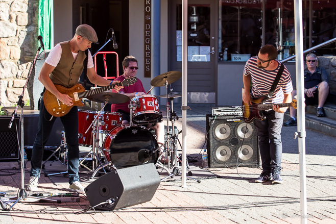
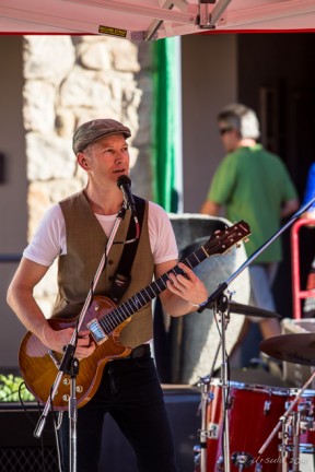
Jimi Hocking’s Blues Machine Late Friday afternoon (17January2014) in Thredbo Village Square,Jimi Hocking warms up the crowd. Sample-sized beer and wine from festival sponsors add to the party the atmosphere.
Jimi Hocking
Rhythm for the Blues Machine
Harmonicas We move inside Santé Restaurant, where Doc Span‘s harmonicas are lined up and ready.
Nick Charles and Doc Span Nick Charles and Doc Span perform their own original works and the classic blues and folk/blues songs of the great duo from the 1940s, Sonny Terry and Brownie McGhee.
Simon Kinny-Lewis Some rocking country blues guitar in the Schuss Bar rounds the evening out for us – although the music kicks on into the wee hours.
Hat Fitz and Cara Early Saturday (18January2014), we made our way up the Crackenback Chairlift to Eagle’s Nest Restaurant, where we – and the rest of the enthusiastic room – are entertained by crowd-pleasers, Hat Fitz and Cara Robinson.
Hat Fitz Queenslander Hat, with his National steel guitar and gutsy gravel voice…
Cara Robinson … is a perfect compliment to the percussion- and flute-playing Irish-born folksinger Cara.
Cara on Flute Cara has a powerful, soaring, effortless voice that fills a room with tears and goosebumps. She’s equally adept telling a story or joke, or playing flute or whistle.
[…] Take Hat Fitz and Cara Robinson, for example. I first saw Hat Fitz perform at the 10th Byron Bay Blues and Roots Festival, in 1999, many years before he met his current wife and musical partner Cara Robinson at (the story goes) a music festival in her native Ireland in 2008. He has a voice of gravel; she has a vocal range and power that often has me choked with tears. Together, they are captivating. My husband and I first saw them together at the 2012 Thredbo Blues Festival, and we made sure to introduce our friends to them at last year’s Byron Bay Bluesfest, and this year’s Thredbo Blues. […]ReplyCancel
[…] 2015) make great excuses to get into Kosciuszko National Park. I’ve said it before: (Summer Blues; All that Jazz; Blues in Colour) I love music in the […]ReplyCancel
[…] a small, unassuming, festival that is about much more than just world-class music (see: Summer Blues; Blues in Colour; Cool Blues – Hot Jazz). As usual, we also delighted in great company, […]ReplyCancel
[…] before, and we’ve seen him there – and at the Thredbo Blues Festival (see: Summer Blues and The Blues in Colour) – and enjoyed him every […]ReplyCancel
[…] a small, unassuming, festival that is about much more than just world-class music (see: Summer Blues; Blues in Colour; Cool Blues – Hot Jazz). As usual, we also delighted in great […]ReplyCancel
Clonmacnoise Cathedral A replica of the West High Cross, the ‘Cross of the Scriptures’, depicting scenes from the crucifixion of Jesus, sits in front of the ruins of the cathedral, originally built in 909 AD.
Religion and religious faith are the heart of Ireland.
So, it seems fitting that one of the most fascinating religious/historical sites sits at the heart of the country – almost dead centre – where the traditional east-west land route crossed the River Shannon. It is also apposite that this site, dating back to the earliest days of Christianity, is still used as a place of worship today.
Cluain Mhic Nois (“Meadow of the sons of Nos”) or Clonmacnoise was founded by Saint Ciarán of Clonmacnoise (sometimes known as Ciarán the Younger, Ceran, Kieran or Queran), one of the Twelve Apostles of Ireland, as a monastery around 543-548. The actual dates vary with the source, but what is constant in the telling, is that Ciarán, who was in his early thirties, died of plague very shortly thereafter.
The monastery, however, lived on. Oenna, one of the men Ciarán converted at the first church he built at Inis Aingin, became Abbot after Ciarán’s death. Under the protection of the powerful provincial kings of Meath or Connacht (at different times), Clonmacnoise became one of the most important religious and educational centres in Ireland, attracting scholars from all over Europe until the 12th century.
Like other centres, Clonmacnoise was regularly attacked and plundered by invaders, including the Vikings and Anglo-Normans. From the 13th century it fell into decline before being destroyed in 1552 by the English. Fortunately, it was designated a national monument in 1877 and is now looked after by Ireland’s Office of Public Works (OPW).
Crosses and Ruins A view of ruined temples and standing high crosses greets us before we reach the car park.
The Pilgrim “Aedh, son of the chief of Oriel, died on pilgrimage. 606 A.D. ~ Jackie McKenna, Sculpt.”
Diorama of Early Life Entry to the extensive ruins of Clonmacnoise is through the Visitor’s Centre, which houses audiovisual presentations explaining the flora, fauna, and landscape of the region, and depicting the early history of the site.
The Cross of the Scriptures The Visitor’s Centre also protects three of the High Crosses found at Clonmacnoise. The Western Cross, also called The Cross of the Scriptures, is probably the best preserved of Ireland’s high crosses. Dating to the early 9th century, the 4 metre (13 foot) sandstone cross was carved in high relief with scenes from the life of Christ.
Celtic Knots The High Crosses were intricately patterned with scenes or more abstract patterns of knots and spirals.
Clonmacnoise Grounds Much of the early monastic village was built in wood and no longer exists, but the extensive stone ruins include a cathedral, a castle, a round tower, and numerous churches (called temples).
Crosses against the Sky Crosses, both replicas and originals, dot the grounds.
The South Cross A replica of The South Cross (the original is in the Visitor’s Centre) in its original position, in front of Temples Hurpan and Dowling.
Celtic Lichen It is and atmospheric and mystical place.
Walls and Windows Looking through the thick walls of Temple Dowling (10th century) to the cross in the adjoining Temple Hurpan (17th century).
“For John Claffey” This cross is relatively new: John Claffey died in 1921; his wife in 1915. Temple Hurpan serves as a burial place for select members of the local parish.
Temple Melaghlin (c.1200) It is said that at least seven Melaghlin Kings are buried under this temple, which is, therefore, known as the King’s Church.
Holy Communion by the River Shannon Clonmacnoise is a living site: normal services are held regularly. In addition, there are two special ‘days of devotion’, both of which attract pilgrims from near and far.
Temple Ciarán The sloping arched doorway at the front provides access to the tiny (4 x 3 metres) temple.
Temple Ciarán Known as an Irish Tomb Chapel, this early masonry church (10th century) was believed to be the resting place of Saint Ciarán.
Clonmacnoise Cathedral Originally built in 909 AD, the cathedral has been added to over the years. The entry door, called the Whispering Arch, is where the monks took confessions.
Saints Dominic, Patrick and Francis Sculptures of Saints Dominic, Patrick and Francis were added above the north door of the Clonmacnoise Cathedral in the 1450s.
Inside Clonmacnoise Cathedral
Cross of the Scriptures (replica) The East Face of the cross depicts the scene of the Last Judgement.
River Shannon Many visitors to the site come in by boat.
Clonmacnoise Castle Our last stop in the area is at the abstract pile of brickwork that is the ruins of Clonmacnoise Castle, built in 1214.
While researching the background to the buildings in the Clonmacnoise monastic community, I came across posts from a number of people who had visited it more than once, and from many who had deep, mystical attachments to the site.
I can certainly understand that. It truly is an enchanting and fascinating place – well worth exploring.
It is a very calming site & not commercializedReplyCancel
Rodolfo Lopez -February 23, 2015 - 8:52 pm
En este momento estoy editando el video de mi visita en setiembre/2013,reviviendo la emoción que me produjo el lugar y aprendiendo el sentido de muchas cosas en estas paginas
Google Translation:
Right now I ‘m editing the video of my visit in September / 2013 , reliving the excitement that gave me the place and learn the meaning of many things in these pagesReplyCancel
[…] was how we decided to include the wild Connemara region of West Galway and the ancient monastery Clonmacnoise – both “Highly Recommended” – in our travel plans. It was while trying to […]ReplyCancel
[…] the day in question, we had spent the morning at the ruins of a centuries-old monastery (Clonmacnoise) and a lived-in castle (Birr Castle), and we were looking for the home of the world-famous Irish […]ReplyCancel
Tracey coughlan -January 11, 2017 - 7:31 pm
Why is the great Coughlans never mentioned. The cathedral is all Coughlans graves. People who have visit clonmacnoice would have notice its actually called Coughlans templeReplyCancel
Hi Tracey,
So it is your ancestors buried there? What a fascinating heritage! It is a wonderful place.
Cheers! UReplyCancel
Dan Holden -December 16, 2025 - 12:59 am
I’m writing an indepth paper on the history/meaning of the Cross of the Scriptures if anyone has information to share. Feel free to reach out via my email address. Slan!ReplyCancel
Splendor Sine Occasu “The Sun Never Sets…” or “Brilliance without Setting” The shield of the province of British Columbia is proudly displayed on the prow of the government-owned ferries.
If you grew up in one of the many protectorates or dominions of the British Commonwealth, and are as old as I am, you will remember a world map in the classroom, covered in pink.
British Columbia, on the west coast of Canada, was the last bit of pink on the left – before the map ended and the lowering sun ran into the international dateline. Those maps harked back to the days in which the sun never set on the British Empire.
Of course, that ship has long since sailed; the sun did set. But, some of the ideals and symbols endure. I found it interesting to look up the elements of the British Columbia shield, which is proudly displayed on the prow of all the provincial ferries. Little changed from the original version drawn in the 1890s, the design reflects the sentiments of the day: the Queen’s royal crest above a shield incorporating an antique crown and the Union Jack above a sun, lowering itself into the the waves of the Pacific Ocean. The “supporters” are the wapiti (elk) of Vancouver Island in the west, and the bighorn sheep of the mountains in the east.
Sun, water and wildlife – and a tip of the hat to the British royalty; the shield sums it up, really. Of course, the old regime pretty much ignored the rich cultural and artistic practices of the local First Nations people. While that acknowledgement is still missing from the crest and shield, symbols originating out of Indigenous traditions can be seen everywhere else.
There is no better place to be than the west coast of British Columbia – the heart of the Pacific North West, especially in good weather. I’d return to the area even if I didn’t have family to visit on both sides of the Strait of Georgia.
If you want to drive, the BC Ferries are the vital links in the road system that get you from inlet to island to peninsula and back – through a landscape of trees and mountains and waterways where no bridges reach.
The Queen of Capilano We watch one of the smaller BC ferries come into dock at Horseshoe Bay, thirty minutes north of Vancouver. Most of the ferries are “queens”, and most have indigenous tribal names. Capilanowas a Squamishchief, after whom many local places were named.
Leaving Horseshoe Bay Ferry travel is very civilised (if rather expensive!): after paying, you can park your car in the queue and wander over to the local shops or restaurants to pass the time before being called back to your vehicle.
In our Wake The waters of Howe Sound are protected and scenic…
Howe Sound Islands … as we wend our way past the islands of Bowen and Keats to the south of us, and Gambier to the north.
Persephone The next day, in the small coastal community of Gibsons, we lunched at Molly’s Reach and had a look at Persephone, the steel logging tug that featured in The Beachcombers, Canada’s longest-running English-language drama. In production from 1972 to 1990, the show put the local area on the map. My mother was an extra in two of the 387 episodes, and my children later watched syndicated episodes in Australia, half a world away.
Welcome to Sechelt The lower Sunshine Coast community of Sechelt, the “land between two waters”, just 25 minutes further up the road, is still home to the Sháshíshálh Indian Band, as well as newer arrivals – mostly retirees from nearby Vancouver. It also boasts atmospheric rocky beaches and lush green parks.
Sunbeams ~ Earls Cove Another day, and another short stretch of drive up the lower Sunshine Coast Highway, through tall douglas firs and quaint coastal housing. After a quick hike to marvel at the “strong waters” of Skookumchuk Narrows, we sit in the afternoon sun, waiting for our next ferry to unload.
Leaving Earls Cove On this leg of the journey, we take a small ferry the 18 km across Jervis Inlet from Earls Cove to Saltery Bay. (I like the hand print that is visible on the window I’m shooting through; someone has been climbing!)
Flying the Flags Three flags flying at the top of our ferry: the Canadian, the Provincial, and the BC Ferries.
Watching Water It is a pleasant – if cool – afternoon on the waters …
Jervis Inlet Waters … and the view is always changing.
Saltery Bay After an hour on the boat, we dock at Saltery Bay, disembark, and drive the 30km up the Sunshine Highway to Powell River…
Powell River Sunset … where we are treated to a magnificent sunset after a delicious dinner.
Queen of Burnaby Bell Early the next morning, we were on another ferry –
Ropes ~ Ship-Shape – this time for an hour and twenty minutes across the Strait of Georgia (the Salish Sea) –
Rusty Chains – between Powell River on the northern Sunshine Coast and Comox on Vancouver Island.
Yellow Cedar Back on land on Vancouver Island, we detoured forty-five minutes north …
Wood Working … to visit the Museum at Campbell River and learn something about the old timber industry.
Red Snapper The museum has an excellent First Nations exhibit, but you can’t take photos inside. I had to content myself with pictures of the artwork in the gift shop.
Blackberries (Rubus fruiticosus) It is the end of July, and the blackberries are still forming. I thought these were salmonberries – the correction is thanks to a sharp-eyed reader. 😀
Driftwood Old logs wash up on the beaches.
Transformations on the Shore A little further down the road, the results of the annual “Transformations on the Shore” chainsaw carving competition are still on display.
Sun Many of the carvings incorporate traditional Pacific Northwest First Nations designs;
Eagle … new renditions of age-old themes.
Although we have travelled around the southern portions of the Sechelt Peninsula and Vancouver Island before, this was the first time we’ve been able to drive the northern parts of the circuit.
I look forward to the day when we have the time to explore it more fully.
Flowers for Offerings With her shoes in her hand, a woman walks through a Burmese Buddhist temple with a large bunch of weeping goldsmith flowers (padeign gno in Burmese) as offerings. Visits to local temples are a part of every-day life in Myanmar.
Religion has been at the centre of countless world conflicts since time immemorial – as I was reminded by an article about religion and politics posted on Facebook this morning. Religion is also integrally entwined with the role politics plays in managing societal organisation and ensuring civil order: in many parts of the world, religion shapes every aspect of people’s daily lives, instructs them on how to behave, and provids a purpose and a focus for their artistic expression.
A short walk through the streets of Mandalay illustrate the religious richness of Burmese traditions.
I had some time to spare before my group was expected to meet for a visit to the marble-carving street – ten photo-enthusiasts under the leadership of photographer Karl Grobl and Burmese guide Mr MM – so I took myself for a wander through an ordinary Mandalay neighbourhood, where, unsurprisingly, I found a temple.
Markets at the Temple Any time you are anywhere near a temple, you will find monks’ robes, candles, offerings and all manner of religious supplies for sale.
The Nuns A pair of Buddhist nuns takes care of one of the market stalls.
Temple Walls It’s only an ordinary temple…
Walking Monk … but it is still a great place to people-watch.
Walking Woman The wet grounds make for nice reflections.
Fading Flowers Offerings include fresh flowers…
Money Flowers … and paper flowers made from Burmese kyat.
Preparing Chew Back outside the temple, a young woman prepares leaves for betel chewing…
Sorting Garlic … while two other women toss garlic to clean it.
Marble Buddha A faded painted Buddha in an empty lot signals that we have reached the marble-carving street.
Perfecting Buddha Creating the large marble buddhas that are seen everywhere in Myanmar is labour-intensive.
Marble-Worker But, in spite of the searing heat…
Marble-Worker … workers will pause for a cheerful smile.
Hands at Work Every section of carving is painstakingly polished and scrubbed…
Burmese Buddha … and the finished products are stunning; …
Burmese Buddhas … beautiful …
Burmese Buddhas … and all subtly different.
Sanding No face masks, no gloves, no protective eye-wear;
Sanding workers have to concentrate carefully …
Sanding … and the heat and dust must take a toll on their health.
Buddhas for Sale As well as the large white buddhas, smaller figurines and prayer beads are for sale.
Crating Buddhas Amid the heat and dust, buddhas are readied for transport.
Washing Towards the end of the road, women on scaffolding wash a large buddha…
Polishing … while another group polishes one.
Buddhas everywhere.
And everywhere, Burmese people celebrating their religion – by making offerings and by making art.
The Last Sun of 2013 Late afternoon at Charlotte’s Pass, in Australia’s Snowy Mountains (31 December 2013).
2013 was a big year in our house – with excitement and challenges; travel and change – but it ended much as it began for my husband and myself: with time out in the Snowy Mountains of Australia, communing with nature.
As visitors to this PhotoBlog know, this is something of a habit for me. I always book some quiet time into the schedule between Christmas and the early New Year; time to look back at jobs completed and things achieved, and to look forward to new goals and unfinished business.
When it is practical, I spend this time in Jindabyne and Kosciuszko National Park (e.g., Snowy Mountain High). We do make it into the mountains at other times of the year, whether it be just to walk or to enjoy the annual Thredbo Blues or Jazz Festivals, but December-January we make a point of visiting. The alpine flowers are out and the weather is beautiful; just the right environment to recharge ones batteries after a hectic year.
So, please join me for some quiet moments in the mountains.
Summer Berries Bullocks Track (18 January 2013).
Kosciuszko Express Chair Riding up to the top of a misty Mt Crackenback (19 January 2013).
Mt Crackenback Looking over the granite outcrops back down towards Thredbo Village (19 January 2013).
Kosciuszko Lookout Trail Walking through the rocks and heath above the treeline towards Mt Kosciuszko, which is still hidden over the hill (19 January 2013).
Silver Snow Daisies (Celmisia asteliifolia) The season peaked early, and by mid January the snow daisies were already past their prime (19 January 2013).
Textured Bark Eucalyptus forests are full of textures and colours: Waterfall Track (20 January 2013).
Stump of a Veteran Waterfall Track (20 January 2013).
Dandelion Make a wish! (19 January 2013)
Alpine Podolepsis (Podolepsis Robusta) At first glance, these can be mistaken for dandelions…
Alpine Podolepsis … but a look at the leaves reveals why they are called “Mountain Lettuce”.
Waterfall Track Just under 6km, this is a delightful walk through the lower eucalyptus forest.
Orange Everlasting (Bracteantha Subundulata) After the silver snow daisies, the everlastings are my favourites: Rainbow Lake Walk (22 January 2013).
Yellow Floating Heart (Nymphoides pelota) Non-natives, the fringed lilies are none-the-less a delightful addition to Rainbow Lake.
Gunn’s Willow-herb (Epilobium Gunnianum) The delicate Gunn’s Willow-herb is easy to miss in the tall snow grass.
Native Bluebell (Walhenbergia) There are at least three kinds of native bluebells in the park; I can never remember which one is which.
Rainbow Lake It is a short walk (3km round-trip) through snowgrass and snow gums to Rainbow Lake – originally a dam to supply water to nearby Hotel Kosciusko, which burnt down in 1951.
Lichen More eucalyptus colours and textures (22 January 2013).
Snow Gum (Eucalyptus Pauciflora) Blossoms The blossoms of the snow gum are surprisingly delicate, considering the rugged conditions they live under (31 December 2013).
The Main Range One of the first things we do on every visit to the High Country is walk up the short Snow Gums Boardwalk to have a look over the Main Range. There is very little snow remaining at the moment (31 December 2013).
Tall Rice Flower (Pimelea Ligustrina) There are delicate colours in every crevice..
Tall Rice Flower (Pimelea Ligustrina) … and delicate flowers on every plant.
Alpine Mint-Bush (Prostanthera Cuneata) The beautiful-smelling Mountain Mint tells me I have arrived (31 December 2013).
I hope you have enjoyed your holiday season, and wish you all the best for a happy, healthy new year.
[…] of Kosciuszko National Park. Usually we plan at least one ambitious alpine walk (e.g.: Bookends on 2013, Alpine Bookends 2014, Illawong Lodge, Guthega, or Summer Walks in the […]ReplyCancel
[…] Lookout; Porcupine Rocks; Mount Kosciuszko Summit; Mount Stillwell; Seaman’s Hut; Waterfall Track; Rainbow Lake; Illawong Lodge; The Old Geehi Huts; etc.), but we usually try to […]ReplyCancel
- Performing the Ganga Aarti from Dasaswamedh Ghat, Varanasi
- Buddha Head from Shwedagon Pagoda, Myanmar
- Harry Clarke Window from Dingle, Ireland
- Novice Monk Shwe Yan Pyay Monastery, Myanmar
Packets of 10 for $AU50.
Or - pick any photo from my Flickr or Wanders blog photos.


 Share the music ~


 Although we have travelled around the southern portions of the Sechelt Peninsula and Vancouver Island before, this was the first time we’ve been able to drive the northern parts of the circuit.


 I hope you have enjoyed your holiday season, and wish you all the best for a happy, healthy new year.


[…] Take Hat Fitz and Cara Robinson, for example. I first saw Hat Fitz perform at the 10th Byron Bay Blues and Roots Festival, in 1999, many years before he met his current wife and musical partner Cara Robinson at (the story goes) a music festival in her native Ireland in 2008. He has a voice of gravel; she has a vocal range and power that often has me choked with tears. Together, they are captivating. My husband and I first saw them together at the 2012 Thredbo Blues Festival, and we made sure to introduce our friends to them at last year’s Byron Bay Bluesfest, and this year’s Thredbo Blues. […]
[…] 2015) make great excuses to get into Kosciuszko National Park. I’ve said it before: (Summer Blues; All that Jazz; Blues in Colour) I love music in the […]
[…] a small, unassuming, festival that is about much more than just world-class music (see: Summer Blues; Blues in Colour; Cool Blues – Hot Jazz). As usual, we also delighted in great company, […]
[…] before, and we’ve seen him there – and at the Thredbo Blues Festival (see: Summer Blues and The Blues in Colour) – and enjoyed him every […]
[…] a small, unassuming, festival that is about much more than just world-class music (see: Summer Blues; Blues in Colour; Cool Blues – Hot Jazz). As usual, we also delighted in great […]