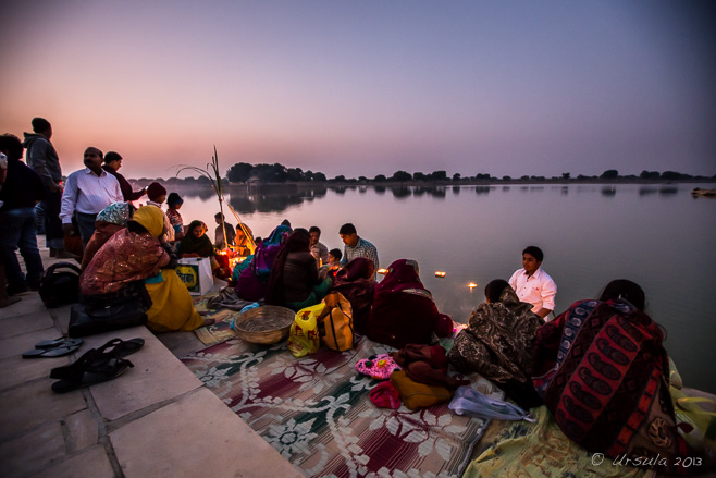
Performing the Chhath Pūjā Standing in the cold waters of Gadsisar Lake, Jaisalmer a husband and wife present offerings to the rising sun.
It has been said that you can not count the number of deities in the Hindu cosmology. And while, technically, they are all manifestations of One Supreme Being, it does make for a lot of festivals and religious observances.
Of course, some gods – and festivals – are more important than others.
Chhath Pūjā, also known as Dala Chhath, is dedicated to the Hindu Sun God, Surya, and Chhathi Maiya, Surya’s wife or consort. Of significant importance, especially in Bihar, northern India, the four days of ritual observances are performed to thank Surya for sustaining life on earth and to ask for favours.
On the last day of the pūjā (Hindu prayer ritual), devotees gather on the banks of a river or pond to give offerings (Arghya) to the rising sun before breaking their fast with family and friends.
Kartika Shukla Shashthi, the sixth day of the month of Kartika in the Hindu Calendar, was November 9th last year. I wasn’t in Bihar – I was in the desert city of Jaisalmer with photographer Karl Grobl, local guide DV, and a small group of photo-enthusiasts – but as a significant number of people from Bihar live and work in the “Golden City” of Rajasthan, it was almost as good.
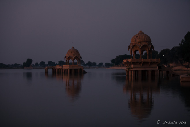
Gadsisar Lake Before dawn, we arrived at Jaisalmer’s man-made lake, which was constructed around 1400 A.D. as a conservation tank.
On the Ghat As early as we were, a number of Indians were already camped out at this popular pilgrimage spot.
Devotees True worshipers follow four days of ritual bathing, fasting and abstinence. These women have been in the waters of the reservoir since 4am.
My Informant Others participate to a lesser extent. This woman, a local English teacher, was happy to give me a place on her family’s mat, and explained the proceedings to me.
Women in their Finery Still others welcome the opportunity to meet and chat …
Mother and Child … and are happy to pose for pictures.
Offerings As the morning gets lighter, offerings are made ready.
Still Standing Parvaitin, the main worshipers, pray for the well-being of their family, and for the prosperity of their offspring.
Smiling Man
Offerings As the sun comes up, families – with the exception of unmarried girls – come together in the water to pour milk over the offerings and say prayers. In this family, the teenaged daughter is the one taking video.
Offerings
Pavilion on Gadsisar Lake
On the Ghats The sun is up; the worshipers share out the offerings, …
Portrait of a Teenager
Portrait of the Boys
Leaving the Pūjā … pile into vehicles and head home for a (strictly vegetarian) feast to break the fast.
Sādhu Chhath Pūjā is the only Hindu holy festival which involves no pandit (priest). We met met this local holy man on our way out of the lake area; he had missed out on sharing in the offerings to the sun, so I bought him a chai before heading home to my own breakfast.
I thoroughly enjoyed my breakfast after such an early start –
Though probably not as much as those Indian people who had assured their family’s good fortunes for another year.
Wow, another fantastic post! Ursula, I love reliving the events through the images you capture…additionally, your thorough research and captivating writing style really bring it all to life again. Bravo!ReplyCancel
Officially starting in Torquay, gateway to Victoria’s “Surf Coast”, and hugging the rugged coastline along the Southern Ocean for 243 kilometres (151 miles) to Allansford, just outside the Victorian regional centre of Warrnambool, The Great Ocean Road is worthy of its listing as an Australian National Heritagesite.
Ocean Road Sign, Torquay After almost two hours of driving suburban motorways, it was a relief to finally reach a signpost for the Great Ocean Road – even if the immediate surrounds seemed inauspicious.
Torquay boasts a “Surf World Museum”, but as we had only three days in which to cover a suggested five-day itinerary from Melbourne to Adelaide, we stopped only long enough to pick up some maps, brochures, and lunch, before heading to our first (of many) beach stops.
Bell’s Beach Waves were rolling in, but not a soul was riding them. Bell’s Beach is a renowned surf beach. I don’t surf, but I’ve seen Bell’s Beach tee-shirts as far away as Indonesia.
Lagoon, Aireys Inlet From another car park, it’s a short walk along a sandy lagoon…
Split Point Lighthouse … and up to the lighthouse affectionately known as the ‘White Queen’.
Split Point Lighthouse As is fitting for a lighthouse visit, the skies were grey, and scattered rains fell. This lighthouse featured in Round the Twist, a popular children’s show that was never missed in our house.
Eagle Rock From the lighthouse surrounds, there are views over the dramatic coastline around Aireys Inlet.
Listed as the world’s largest war memorial, the Great Ocean Road is remarkable for more than just its magnificent scenery. Built by some 3000 returned First World War Australian soldiers and sailors (“Diggers”) between war’s end and 1932, the road served as both a means of employing returned servicemen, and as a tribute and memorial to their fallen comrades.
The Diggers by Julia Squires At the Memorial Arch, a statue commemorating “The Diggers” who built the road was unveiled in 2007.
Seagull There is no better place to find fresh fish and chips than on a harbour where the boats come in. We stopped for an early dinner at the waterside in Apollo Bay.
Last Light We tucked in for the night at Cape Otway Lightstation, at the southern-most point in the Cape Otway National Park.
Cape Otway Lightstation Operating from 1848, Cape Otway is the oldest surviving lighthouse on mainland Australia.
Bicycle Although decommissioned in January 1994, the Lightstation and grounds are open for exploration and tours.
Cape Otway Desk Historical and other informative displays are mounted in the various well-maintained cottages.
Koala While driving the 12 km back from the Cape Otway Lightstation through the Cape Otway National Park to rejoin the Great Ocean Road, we saw our first wild koalas in the tree-tops.
Koalas Remarkably hard to spot from the ground through the gum-tree branches and foliage against the bright morning sky, most of the koalas seem to be asleep. Their fur and funny faces make them look cute and cuddly, but the same claws that keep them from falling out of trees can inflict nasty injuries.
Gibson Steps Descending the 86 steep stairs to the bottom of the Gibson Steps affords a fabulous view, from the beach up, of looming rock stacks – a taste of what is to come.
Incoming Waves The colour of the Southern Ocean as it laps onto the beach at Gibson Steps is remarkable…
Cliff Face … as are the striations on the steep cliff-face behind us.
Next Stop: The Twelve Apostles It seems there never were twelve rock stacks – but little matter! They are magnificent, and easily accessible from the car park.
Twelve Apostles The coastline and rock formations seem to stretch for ever, and the walkways follow…
Twelve Apostles … providing breathtaking views in both directions.
The Loch Ard Gorge Area Just ten minutes further along the “Shipwreck Coast”, still in Port Campbell National Park…
The Loch Ard Gorge Area … there are more carparks, more walkways, and more stunning views.
Loch Ard Gorge Loch Ard Gorge is named for the clipper Loch Ard, one of many ships wrecked in the area.
Breakers The Loch Ard ran aground on nearby Muttonbird Island in 1878. The two survivors (from 54 passengers aboard) made it into this cove, and somehow one of them, 15 year old Tom Pearce, climbed out of the gorge to get help. Watching the waves break, both inside and outside the cove, and looking up at the steep walls of the gorge, it seems an impossible feat.
We, of course, had the benefit of another steep, narrow, staircase – but even then, the assent out of the gorge felt like hard work.
There were countless other paths to follow, and both inland and coastal areas to explore, but we had, sadly, run out of time. We continued our drive west, and didn’t even see a marker when we left the magnificent Great Ocean Road behind us at the other end.
But we now know what to look out for, and when we have more time, we’ll be back…
[…] in the earth’s layers to produce these sea stacks. We were reminded of our visit to the “Twelve Apostles” in southern Australia earlier in the […]ReplyCancel
[…] had just driven the length of Australia’s Great Ocean Road, a drive through scenery so magnificent that it rates its own UNESCO World Heritage listing. […]ReplyCancel
[…] – mostly because of habitat loss, and I’ve only ever seen them once in the wild (see: The Great Ocean Road). Even in zoos they can hide, so it was nice to get so close to these balls of […]ReplyCancel
Galloping into the Year of the Horse Featured sculptures: Flower Dome, Gardens by the Bay. (iPhone4S)
February 14th was a special day this year: there was a full moon.
Across Western countries, the fourteenth was Valentine’s Day, that most romantic celebration of love, or most cynical expression of consumerism, depending on your perspective. In North America, the full moon was the “Snow Moon”, named for the heavy snowfalls February usually brings.
In Theravada Buddhist countries, the February full moon signals the holy day of Makha Bucha(Māgha Pūjā), the anniversary of the day when the recently-enlightened Buddha was spontaneously visited by 1,250 disciples.
And, in any country with a significant population of Chinese heritage, this full moon marked the last day of the 15-day celebration of the Lunar New Year: bidding farewell to the Year of the Snake, and welcoming the Year of the Horse.
Lunar New Year, also known as the Spring Festival is a BIG deal. In China, many offices close for a full week or more as families travel to get together to celebrate. In Singapore, where we happened to be this year (for the Singapore Airshow), Chinatown was ablaze with lights and colours, and the restaurants were full. Internally-lit giant pink horses pranced and galloped down the central boulevard of the main street. Golden coins floated overhead, and lucky dragons with their accompanying drummers were never far from view.
Even the Singapore gardens got in on the Lunar New Year festivities.
It was the wooden horse sculpture on the posters for the Gardens by the Bay that drew me out to explore this relatively new complex. The 101 hectare (1,010,000 m2) redevelopment garden-park consists of three waterfront gardens and a conservatory complex; well beyond what I could manage on a sticky-humid Valentine’s Day.
I settled for a visit to the two cooled conservatories: the Cloud Forest and the Flower Dome.
Magnificent Bull by Walter Matia Sculpture is everywhere around the garden complex.
Supertrees Overhead, the 25 – 50 metre vertical gardens loom against a heavy, humid sky.
The Falls Inside the Cloud Forest Conservatory, the world’s tallest indoor waterfall falls 35-metre (115 ft) to the base of Cloud Mountain.
Orchid The entry level is lush with moisture-loving exotics.
Violets
Walking the Cloud Walk High overhead, visitors wind around the elevated walkways.
Walking through the Waterfall Across a small lake, people can be seen walking under a waterfall.
Orchid
Plantpot Man Timorese wooden sculptures are scattered around the Cloud Forest.
Impossibly Beautiful Orchids
Mushrooms
The Lost World View through to the Marina Sands hotel.
Pond in the The Lost World … at the top of the Cloud Forest.
Venus Fly Trap
Walk in the Clouds
Flowers in a Tumble
View from the Lost World, Cloud Forest… … like something from Pandora, the Supertrees are visible through the waterfall…
Under the Waterfall
Gardener In the large, cool Flower Dome, the mild, dry climates from various regions around the world are replicated.
Cactus The succulent garden within the Flower Dome contains various cacti, baobabs, and other succulents from the world’s arid zones.
Eastern Cowboys Weathered wood horsemen from Timor Leste.
Golden Coins In a central display area, the Lunar New Year is being celebrated.
Mother and Foal
Galloping Horses Featured sculptures: Flower Dome, Gardens by the Bay. Happy New Year!
Black Eagles in Diamond Formation How do they do that? The team aerobatics demonstration from the Republic of Korea Air Force (ROKAF) Black Eagles was impressive in its precision.
Is there anything more magical than flight?
… being transported through the air by an overweight contraption that somehow lifts itself (and you) into space? … watching graceful machines do impossible acrobatics high overhead?
I love airplanes. I love their shiny, reflective surfaces; their lines and curves. While I know almost nothing about the actually mechanics of lift and thrust, I love flying – and watching airplanes in flight.
It has been a while since I’ve been to a serious air show (Farnborough 2010), or even a local display (Merimbula 2012), so when the chance came to tag along to the fourth biennial Singapore Airshow, and attend the opening, I jumped at it.
There were acres of polished shoes and buttons, metres of gold braid, and more epaulettes than you can shake a stick at attending the opening reception and the first day of the show. Top brass from flying forces around the world had come to look over each others’ innovations. Somewhere in the back-rooms, deals have no doubt been struck. I, however, was happy to just wander around with the cameras and gawk at the Aerobatic Flying and the Static Aircraft Displays.
RSAF Black Knights Trailing decorative plumes of smoke, the Republic of Singapore Air Force (RSAF) military aerobatics team in their F-16C Fighting Falcons, opened the show.
Black Knights in Formation The local team showed off a number of manoeuvres against an overcast Singapore sky.
Photographer As the first flying display finishes, people go back inside the Changi Exhibition Centre, leaving just the local press photographers and ground crew outside on the pavement.
Flags Twenty-two countries from around the world are represented at the Airshow by government and corporate exhibitors.
Arrivals People continue to arrive at the Airshow throughout the morning.
Dignitaries in the Hall Jimmy Lau, Managing Director of Experia Events, the organisers of the Singapore Airshow, describes the key exhibits to an entourage of dignitaries, including Singapore’s Defence Minister Ng Eng Hen and Transport Minister Lui Tuck Yew.
Checking out the Fighters With no “public” allowed at the Airshow yet, press and trade exhibitors take advantage of the opportunity to test out the equipment that are part of the Static Display.
Curves and Circles Looking at the engine on Airbus‘ new A350; I like the repeated patterns.
American C17 Transport A visiting officer chats to American Airforce personelle.
Bombardier Q400 Cockpit Even when the plane is on the ground, it is a buzz being on the inside, looking out.
Boeing AH-64 Apache Attack Helicopter
F18-F Super Hornet Back at the aerial displays, an Australian RAAF pilot puts a Super Hornet through its high-speed paces.
South Korean Supersonic T-50s Not-so-far overhead, the ROKAF Black Eagles roar into the air space.
Republic of Korea Air Force Black Eagles Could they be more perfectly aligned?
South Korean ROKAF Team Aerobatics Or closer together?
South Korean Supersonic T-50s Could they be any prettier?
ROKAF Black Eagles Or any more spectacular?
ROKAF Black Eagles They leave us with coloured hearts and fans.
Russian Yak-130 Two-Seater The Black Eagles are a hard act to follow, but the Russian pilots perform some impressive loops and spins…
American F-16C Fighting Falcon … as does the American in an F-16C Fighting Falcon.
MV-22B Osprey The crowd watches as the United States Marine Corps tilt-rotor aircraft hovers overhead, before transitioning to fixed-wing mode.
TNI-AU Jupiter Aerobatic Team The Indonesia Aerobatic Team enters, wing to wing, in their red and white KT-1B Wongbee aircraft.
TNI-AU Jupiter Aerobatic Team They demonstrate a number of patterns and manoeuvres…
A350 Airbus … before clearing the way for the beautifully quiet, wide-body Airbus.
A350 Airbus The behemoth is pretty impressive on the ground, too.
Lockheed C-130 Hercules Visiting military inspect cockpits and hardware; like a magpie, I’m attracted by the shiny bits.
EC130 Airbus Helicopter Representatives are on hand to explain the latest innovations, like the unevenly spaced blades on the tail fan on the EC130.
Twin Otter Series 400 Turboprop I’d happily take one of these home…
[…] month, after a week in the ultra-modern high-rise city-state of Singapore (Magical Flying Machines and Gardens by the Bay), my husband and I took a side-trip to Sumatra, Indonesia’s largest […]ReplyCancel
Looking over Bagan at Twilight It’s a landscape with soul and atmosphere – no matter how many pictures one sees, there is nothing like being there.
What an amazing place Bagan must have been in its heyday!
“Bagan is a gilded city alive with tinkling bells and the swishing sounds of monks’ robes”
– attributed to Marco Polo‘s late-12th-century account.
Probably founded in the mid-to-late 9th, the city was the political, economic and cultural capital of the Pagan Empire for 250 years, and would have been at its height when Marco Polo saw it. A prosperous cosmopolitan city, it was a centre for religious and secular studies, attracting monks and students from as far as India, Ceylon and the Khmer Empire (Wikipedia).
“It is estimated that as many as 13,000 temples and stupas once stood on this 42 sq km plain in central Myanmar…” The Pagan Empire collapsed in 1287 after repeated Mongol invasions, leaving the sacred buildings almost empty, except as destinations for pilgrims. Many less-visited sites fell into ruin. Continual earthquake activity – over 400 earthquakes were recorded between 1904 and 1975 alone – has caused further collapse. Of the estimated original 1000 stupas, 10,000 small temples, and 3000 monasteries, only about 2200 temples and pagodas remain in various states of disrepair.
Those remaining buildings, however, are magic. They belong. They grow out of the flat plains beside the Ayeyarwady (Irrawaddy) River organically. The air is hot and dusty, making the whole scene surreal.
Climbing Shwesandaw Pagoda In the heat of the afternoon we climb the steep steps of the classic “sunset temple”, where tourists gather every evening to watch the sun go down over the Bagan Plains.
Nothing prepared me for my first view over the extensive Bagan Plains, as I, nine colleagues, photographer Karl Grobl, local guide Mr MM, and countless local and international tourists, looked for optimal positions on one of the five tiers of the Shwesandaw Pagoda. Built by King Anawrahta in 1057, this is now a popular “sunset temple” because of its central location, affording 360° outlooks over the ruins.
Thatbyinnyu Temple Between us and the distant Ayeyarwady (Irrawaddy) River, the Thatbyinnyu Temple stands out to the north. The tallest of the pagodas, it was built in the 12th century.
Sulamani Temple Sulamani Temple, built in 1183 by King Narapatisithu, sits to the east of us amid the arid, dusty fields of Minnanthu.
Bagan Stupas dot the landscape all around.
Looking over Bagan I had carried my tripod across three continents so it would be with me on this trip. I’d humped it on and off buses and planes, and lugged it up the steps of Shwesandaw Pagoda – only to discover that a vital part had somehow gone missing and it was useless to me. It was a bit humbling, therefore, to notice that not everyone brings even a camera.
Newlyweds Bagan is still a pilgrimage site and a special place for Burmese, like this newlywed couple.
Dhammayangyi Temple Darkening skies loom over the incomplete Dhammayangyi Temple, which itself has a dramatic history. The largest of the temples, it was commissioned by King Narathu to atone for his sins of assassinating his father, brother, and wife. The story goes that he also had a bricklayer put to death because the tradesman’s work was not good enough. Building on the temple stopped when the King himself was murdered.
Stillness A visiting monk takes in the scene.
Ananda Temple Bagan’s holiest temple, Ananda, or “boundless wisdom”, was built by king Kyan-zit-tha in 1091.
Bagan The stupas and their surrounds are constantly changing colour in the lowering light. The dry climate has helped preserve the essential structures, but wind and dust have scraped away the original stucco coatings, leaving the graceful brickwork exposed.
Pony Carts Pony carts and tour buses wait at the bottom of the temple steps.
Falling Light As the evening light falls, the mists rise on the Ayeyarwady River and the temples start to disappear into the trees and mountains.
Tender Pinks Pink and blue evening skies replace the grey …
Pink Sky …over Dhammayangyi Temple.
Layers Temples, trees, mountains and clouds layer into the distance.
Bagan Skyline As the day ends, temples are silhouetted against the darkening sky.
Under Lights We resort to flashlights to make our way back down the the steps of Shwesandaw Pagoda as darkness falls all around. In the distance, Ananda Temple is flood-lit against the night sky.
It is a magic place, and it was hard to leave – but fortunately, we were coming back the next day. I couldn’t wait!
Awesome post! Ursula, you do a fantastic job with your images and your words! Thanks for sharing with us…it’s awesome to relive the experience through your eyes and thoughts. Wow!ReplyCancel
Dietmut, I’m always pleased to bring you good memories!
Karl, thanks so much for your “visit” and praise. I hope MM is enjoying the tripod! 😀ReplyCancel
[…] all its temples, however, are ruined relics of the Pagan Empire (9th to 13th Century). Others – like the beautiful Shwezigon Pagoda – are still living, breathing […]ReplyCancel
[…] magnificent, pagoda-studded plains of Bagan (A Living Landscape) sit in a curve in the Irrawaddy (Ayeyarwady) River, in a rain shadow between the low coastal […]ReplyCancel
Amazing photos taken during the sunset! Bagan has so many spots to take great photos both for the sunrise (of course from the balloons) and sunet!ReplyCancel
- Performing the Ganga Aarti from Dasaswamedh Ghat, Varanasi
- Buddha Head from Shwedagon Pagoda, Myanmar
- Harry Clarke Window from Dingle, Ireland
- Novice Monk Shwe Yan Pyay Monastery, Myanmar
Packets of 10 for $AU50.
Or - pick any photo from my Flickr or Wanders blog photos.


 …but it would never fit in the garage.


 It is a magic place, and it was hard to leave – but fortunately, we were coming back the next day. I couldn’t wait!


Wow, another fantastic post! Ursula, I love reliving the events through the images you capture…additionally, your thorough research and captivating writing style really bring it all to life again. Bravo!
Thanks, Karl! I’m glad you enjoyed it. I have a photo of you and the Sadhu I’ll send through as soon as I have Internet.