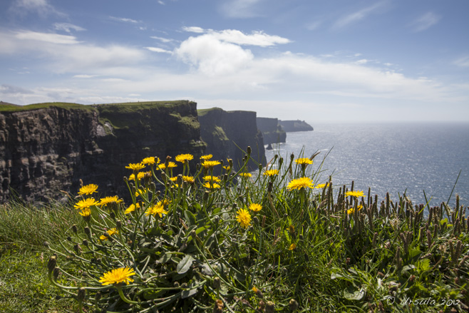
 Dandelion Cliffs
Sunny dandelions greeted us as we climbed the walkway to view the magnificent Cliffs of Moher, County Clare, Ireland. It was pouring.
Of course it was! It rained every day of our visit to Ireland last June. Not all day, but every day.
The silver lining was that were were going to be comfortably seated on a bus tour of County Clare all day, and not walking the wilds of the Dingle Peninsula, County Kerry, as we had been the day before. And, it IS that rain, after all, that makes Ireland the “Emerald Isle”.
We were meant to be heading into some of Ireland’s “most stunning scenery”. So, we picked up our umbrellas, packed our raincoats, and crossed our fingers.
It was still pouring when we arrived at our first brief stop at the ruins of Leamaneh Castle; my husband (holding the umbrella) and I (wielding the camera) were the only members of the tour group who even got out of the bus.
 Leamenagh Castle Ruins
The original Leamenagh Castle was built around 1480 by one of the last High Kings of Ireland. The manor house was added in 1648 by Conor O’Brien and his wife, Máire ní Mahon. Connor died early, and his widow became known as “Máire Rúa” (Red Mary) due to her flaming red hair. She is one of the most infamous women in Irish folklore, probably because she was able to retain her estate via two politically astute marriages. The rain continued as we pulled up to our second, longer, stop at Caherconnell Stone Fort, a stone ringfort dating back to 400 AD. We braved the wet and took the self-guided tour through the magnificent stone ruins.
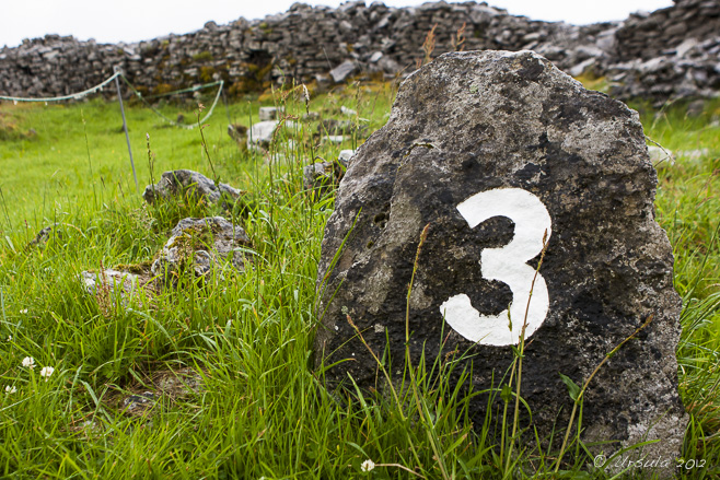 Caherconnell Stone Fort
The self-guided tour takes the visitor through the ringfort, built by farmers around 400 AD and left much as it has been found.  Walls of the Fort
Like other ringforts, Caherconnell was probably built as a defence against animals and raiders. Almost perfectly round, and between 140-145 feet in external diameter, it would have housed a small settlement. Hawthorn
Ringforts are commonly referred to as fairy forts: fairies live in the forts or in the hawthorn trees that grow in them. It is considered unlucky to cut these trees down. Ferns
The walls are 12 feet thick, built from large blocks, as much as three feet long and two and a half feet high. This makes them a perfect home for moss and ferns. The rains eased off but the grey skies hovered for our third stop at a portal tomb: the fascinating Poulnabrone Dolmen – a neolithic burial site probably dating between 4200 BCE and 2900 BCE.
Poulnabrone Tomb
Poulnabrone dolmen (Poll na mBrón in Irish, meaning “hole of the quern stones”) is a neolithic portal tomb thought to date to 3800 BCE. Poulnabrone Tomb
The twelve-foot slab-like capstone sits on slender portal stones. The chamber underneath was the last resting place for almost thirty adults and children, as well as various personal items. Limestone Pavement
The porous limestone pavement around the tomb is pockmarked and slippery with moss and moisture. I was thrilled to stop for lunch overlooking Galway Bay, not only because I was hungry and and the food was terrific, but because I could muse about my ancestors who had emigrated from across those same waters only a few generations before.
Galway Bay
Calm waters and a patch of blue sky greet us at our lunch stop in Ballyvaughan Village. Monks Pub
Justifiably famous for its seafood, the pub was a welcome stop. As the skies cleared further and the sun came out, we continued southwest across the Burren (Boíreann, Irish for “rocky place”) and stopped for a scramble across the glaciated limestone karst “pavement”.
The Burren
Ponies graze on the short grasses that grow in the sparse soils atop the limestone rocks. Stone Wall Still Life Found: Stones and Flowers
Livestock love the Burren because the limestone holds the heat. Flowers in the Fissures
The vertical fissures (grikes) hold water, supporting pockets of plant life. Puddles of Life Bus on the Burren
Our bus sits on the Black Head Coastal Drive, awaiting our return, so we can drive to our last stop. Cliffs of Moher
Our final stop is at the stunning 214m (702 feet) tall Cliffs of Moher – thank heavens the sun is shining! Curving Cliffs
The cliffs, which have been used in numerous movies, including The Princess Bride (1987), stretch for 8 kilometres (5 miles) along the Atlantic coast. Information Centre
The Visitor’s Centre, featuring informative displays and stunning photographs, includes cafeterias, restrooms, and a gift shop. It is built into the hillside, but surprisingly light and airy inside. O’Brien’s Tower
In the other direction lies O’Brien’s Tower, built in 1835 by Cornelius O’ Brien, and used as an observation tower. Cliff Tunnel
Comprised of bands of Namurian sandstone, siltstone, and shale, the cliffs are wonderfully varied, and noisy with nesting bird life. Dandelion Cliffs
One last look at the towering cliffs, and it is time to return to our lodgings in Shannon. The Great Hunger
On the way home, we stop briefly at the statue of an orphan child at a Poorhouse door – a grim reminder of another facet of Ireland’s long and rich history. It was a typical Irish day: starting in rain and ending in brilliant weather.
We heard historical tales – ancient and modern – told with a mixture of poignance and humour. We experienced remarkable sights, natural and man-made.
And, it goes without saying, we ate and drank well.
Sláinte!
Pictures: 28June2012
Posted in History,Ireland,Landscapes,Nature,TravelTags: blog,Co. Clare,history,nature,Photo Blog,ruins,scenery,travel,Travel Blog,Ursula Wall
Market Fresh!
There is always an array of colourful fruit and vegetables at the morning street market. It’s just a simple burmese morning market – in a dirty dusty street somewhere in Mandalay. Most of the vendors are seated on the ground on woven bamboo mats. The rubbish and the dogs threaten to encroach on the wares for sale.
But, the vegetables are fresh, and the smiles are freely given.
I love exploring the markets in Asia. As tricky as they can be to navigate and photograph, they are a feast for the senses and the camera.
I just couldn’t tell you exactly where this one was!
Karl Grobl, our photographic mentor, and Mr MM, our burmese guide, had dropped us (ten enthusiasts with cameras) off the bus somewhere in the Mandalay area and sent us off to explore…
Waiting for a Sale
A vendor sits on the ground, surrounded by her beans. Sprouting
Many of the beans and legumes are sprouting. The Sale is Made. At the Butcher’s
The selection is small… Butcher’s Block
… but attention is immediate. Fresh-Water Fish
Caught daily in the rivers nearby. Sales Lady
A typical burmese woman: sporting thanakha, lucky flowers and a big smile. Fresh Flowers Young Lad
Managing a morning market is a family affair. Let the Procession Begin!
There is some sort of Buddhist celebration going on… Bell Gong
The noise from the flat gong is amazing loud – but the locals are used to it! Bell Carrier Rubbish in the River
A waterway, almost choked with floating rubbish, separates the market from the rest of town. Monk on the Bridge Man on the Bridge Groceries on the Bridge Barrels
I have no idea what these barrels contain, but I loved the colours. Market Scene
Typical street market street scene, complete with motorcycle, local dog, and elegant women walking tall with baskets on their heads. Friends
Smiles are everywhere. Bicycle
Draped in tarps, a precious bicycle sits parked in the rubbish behind the main market “stalls”. Boys with ‘Tude
Some young men on the back of a delivery truck watch me… Wreathed Like a Caesar
… and are quick to flash that famous smile. Burmese Kyat
Returning to the start of the market, I find the first vegetable seller with her hands full of money… Veggie Seller
… she’s happy and relaxed now that she has made several sales.  It was impossible to get lost – this market wasn’t very big. It was impossible to get lost – this market wasn’t very big.
It was also impossible to leave without smiling – in spite of their simple surounds, the people in the markets were friendly and welcoming.
A lesson for us all?
Keep Smiling!
Pictures: 15Septemeber2012
Posted in Culture,Every Day Life,Myanmar,PortraitsTags: blog,environmental portrait,environmental portraits,fruit and vegetable,market,markets,people,Photo Blog,portrait,portraits,travel,Travel Blog,Ursula Wall
Like a Painting
A great blue heron (ardea herodias) flies over the marshy shoreline of Lake Kissimmee. It’s a concrete-and-plastic jungle…
So much of the area around Kissimmee and Orlando in Florida is interconnecting highways, theme parks, condominiums, fast food, and tacky souvenir sales. It is pretty easy to think there is nothing else.
But, you can escape – even if only for a few hours.
It was time: we’d been in Kissimmee several days and I needed to shake off the pre-packaged kitsch. As it turns out, there are tour operators offering airboat rides not too far away. So, in spite of the rain clouds, we set off south, off the major roads, and towards Lake Kissimmee, which sits at the upper-most end of the watershed that feeds the Florida Everglades.
We’d decided on Kissimmee Swamp Tours, and – like a large percentage of TripAdvisor participants – ended up very happy with our choice. It was an hour-long drive to the office: some of it gravel, past large estates and horse studs and through brilliantly green farmlands. It felt like we had entered another world – a breath of fresh air after the neon lights, garish paint, and wall-to-wall cars on US Highway 192.
Once we were fitted into our two-way-radio headsets, we set off – just us and Mark, our operator and guide – across the lake and into the sea of grass and pond lilies.
The birdlife was fabulous! I have neither the patience nor the lenses for really good bird photography, and the constant vibration of the airboat, plus the rainy and overcast weather made for additional challenges… but I can’t resist sharing a “taste” of this marvellous place.
The Airboat
Our six-seater airboat waits to take us out over Lake Kissimmee. A Gator
Within minutes, we spotted our first huge American Alligator (alligator mississippiensis). Pastoral
The red beak, face and legs of the American White Ibis (eudocimus albus) contrast markedly with the impossibly green fields. Sandhill Crane
One of a pair of two-meter cranes (grus canadensis) strides through the water hyacinth – his life-mate is not far behind. Showing Off
A great blue heron (ardea herodias) fans its wings on a grass island. Flight
A great egret (ardea alba) wings across the lake. Small Alligator
Alligators on Lake Kissimmee come in all sizes. Snail Kite – with Snail
The locally-endangered snail kite (Rostrhamus Sociabilis) is dependent on the apple snail for food. Snail Kite
The kites are tagged and tracked to monitor their numbers and movements. Snail Kite
The sharp, curved beak allows the kite to get into the snail shell. Purple Swamphen
It is the big feet that keep the swamphen (porphyrio porphyrio) from sinking. Mr and Mrs Grackle
The lake is home to numerous nesting pairs of great-tailed grackles (quiscalus mexicanus). Snakebird
The snakebird (Anhinga anhinga) is not able to oil and waterproof its wings, and needs to dry them out. Captain Mark
Our knowledgeable boat operator had studied environmental science and clearly loved the lake. Barely Visible
Even when they are not diving and holding their breath, gators are hard to spot. Incoming Squall
The pond lilies and sawgrass marshes stretch out under a threatening sky… We did get wet. Spatterdock…
… or yellow pond-lily (nuphar advena) grows all over the lake. Snowy Egret
An egret (Egretta thula) picks its way over the mud. Apple Snail Eggs
Snail kites live almost exclusively on apple snails (pomacea paludosa), so these pink egg clusters are a good sign for the lake’s ecology. A Patch of Blue
Two least terns (sternula antillarum) are startled into flight by our arrival… American White Pelican
… as a pelican (pelecanus erythrorhynchos) soars past. The Pier
Too soon, we are back on the pier. Killdeer
This spunky killdeer (charadrius vociferus) decided to nest in the middle of the Kissimmee Swamp Tours’ driveway! A short length of “danger” tape keeps visitors from driving over her.  “Everything else is just an Airboat Ride,” according to Kissimmee Swamp Tours advertising. “Everything else is just an Airboat Ride,” according to Kissimmee Swamp Tours advertising.
And they are right! We took another airboat ride, further south, on the Everglades themselves and we didn’t have anywhere near as good an experience.
Beautiful place – sure beats the tourist highways not so far away!
Happy Travels
Photos: 28May2013
Posted in America,Animals,Nature,TravelTags: animals,bird,blog,boats,nature,Photo Blog,travel,Travel Blog,Ursula Wall,water
Spirit Island
One from my Bucket List! This scene is known to every Canadian from postcards and calendars. It’s an image all Canadians, and many people around the world, recognise: the tiny island with its tall lodgepole pines, sitting in the clear turquoise waters of Maligne Lake and surrounded by the snow-capped glacial peaks of the Rocky Mountains.
I’ve known this place from pictures all my life, and have waited a long time to visit Spirit Island for myself.
I have a love affair with Canada’s Rocky Mountain Parks (Banff, Jasper, and Yoho National Parks) and will go to them at any opportunity. I used to visit Banff regularly, but it was lucky that we had planned, months ago, to drive much further afield – north – to Jasper.
On Thursday, June 20, 2013, just two days before our arrival into Alberta, major rainfall closed roads, forced the evacuation of downtown Calgary, and cut Banff off for days. On our drive north to Edmonton, we drove past scenes of heartbreaking inundation. The TransCanada Highway was closed, and no one was getting in or out of the Banff area.
It was still raining as we continued north to Edmonton and west to Jasper. But, the Rockies are magnificent, even in the wet.
In spite of heavy cloud cover, the rains held off the day we drove the two hours from our cabin to the iconic Maligne Lake.
It’s a stunningly beautiful place, with an “evil” name: Father Pierre-Jean De Smet (1801–1873) named the river that feeds the lake “Maligne” (malignant, evil, or wicked) River. Against the advice of locals, he had tried to cross the waters, turbulent from the spring melt, and escaped (only barely) with his horse and his life.
Our trip was much easier: after a late lunch at the visitors’ lodge, we took the 90 minute boat trip out to Spirit Island, “one of the most photographed locations in the world.”
Gray Jay (Perisoreus canadensis)
A cheeky little Canada Jay (Grey Jay or Whiskey Jack) watches to see if we will drop any tasty morsels. Camp Robber
Also known as a Camp Robber, the little bird gives up on us, and eyeballs another diner. Boat House Wet Spring
The boathouse is dark inside: atmospheric and flooded. Kayaks
There are plenty of boats for rent if you want to tour the lake yourself. Boat Dock
We opted for the easier, motorised trip. Captain Gregg
A youthful looking Gregg greets us at the dock. In the Boat
It is a popular tour, and the boat is full as it cruises through the Rockies. In our Wake
Another boat heads back to the dock as we cruise Maligne Lake. Fly the Flags Kirsten and Gregg Mountains all Around
Our commentator Kirsten entertained us with in-depth information about the area. Glaciers
As gray as the overcast day, the glaciers, high in the mountains, can be hard to see. Spirit Reflections
Finally! We arrive at the tour’s highlight: Spirit Island, and we get off the boat for a short walk. There is just enough time for pictures … … before we head back through the Rockies… Just Stunning!  I’ve moved Maligne Lake off my Bucket List, and onto my “Gotta go back when I have more time” list. I’ve moved Maligne Lake off my Bucket List, and onto my “Gotta go back when I have more time” list.
Truly a place to see – at least once.
Happy Travels!
Pictures: 24June2013
Timeless Calm
A modern chedi stands among ancient temple ruins, Inwa Island, Myanmar. Away from the gilded and jewel-bedecked temples filled with monks in maroon robes and nuns in pale pink, Myanmar hides a quiet, almost idyllic, rural landscape dotted with ancient ruins.
Just 21 km south of Mandalay, nestled in the confluence of the Myitnge and Irrawaddy (Ayeyarwaddy) rivers, across from the busy monasteries and shiny temples of the Sagaing Hills, you will find Inwa Island. A trip to the island is like a trip back in time.
Late last September, my travel companions in Myanmar – a group of photography enthusiasts, photographer Karl Grobl, local guide Mr MM – and I, piled into wooden boats and plugged our ears against the noise of the outboard motors. Looking nonchalant, the driver of the boat I was in alternated between steering the outboard with his foot and by hand, as he landed us safely on the muddy bank that passes for a pier.
Like a model in a fashion shoot… …our boatman stands against the sky Irrawaddy River Boatman At the Inwa Island “dock”, we were met by the usual assortment of locals with trinkets for sale, and a “fleet” of pony carts and their drivers to transport the day trippers around. The unpaved roads were muddy and wet; it was easy to see why horse carts are the preferred tourist transport on the island.
Pony Carts Officially called Ratanapura (City of Gems), the artificial island was created by Prince Thadominphya in 1364 to be home to the imperial court of the ancient Kingdom of Inwa (also known as Innwa, Ava or Awa). It was the capital during five separate periods from the 14th to 19th centuries, before being finally abandoned in 1839 after several major earthquakes. No other city in Myanmar has been the seat of government for so long.
Ruins among the Fields
Our first stop was at the Yadana Hsimi Pagodas. Farming Couple
Land around the temple ruins are ready for planting. Buddha Chedis A Young Visitor Gargoyle
Beautiful stone lintels survive around the ruins, Yadana Hsimi Pagodas. Buddha in the Ruins Washing at the Well
There is always life around temples; whether they be new or old ones. Our horse-cart is ready to take us to the next place of interest. Our second stop was across the island, at the Bagaya Kyaung or ‘Star Flower Monastery’, a beautiful old teak building, ornately carved and supported on 267 massive teak posts. Built in 1834, the monastery is still in use today as a classroom for the village children.
Reflections at the Temple
A tree-lined road approaches Bagaya Kyaung… ‘Star Flower Monastery’
… the wonderful teak temple, originally built in 1834 to educate the royals. Monastery Roof
Typical Burmese-style roofline. Buddha Shrine
A small chedi, with a smaller buddha. Monk in a WIndow Little Monks
Novice monks try to stay awake to do their school work inside the dark temple. Gossip
Outside the monastery, vendors chat while waiting for the tourists to come. Mango Bowl
As soon as tourists emerge, vendors are ready with their wares. Incoming Pony Carts Too soon it is time to get back in our horse carts, to ride back across the wet bumpy roads and past the peaceful rice paddies, to our waiting motor boats.
Outgoing Horse Cart Woman in the Rice Fields The Watchtower
Nanmyin, the masonry watchtower, damaged by the 1838 earthquake, is all that remains of the Bagyidaw palace. Back at the Dock Truly a charming and peaceful place –
a reminder of simpler times.
Happy travels!
Pictures: 14September2012
Posted in History,Myanmar,Rural,TravelTags: architecture,blog,buddhism,buddhist,Myanmar,nature,Photo Blog,ruins,rural,temple,travel,Travel Blog,Ursula Wall,worship
« Older posts
Newer posts »
|


")
