Indian Rhododendron on the Sumatran Mountainside Overlooking the town of Berastagi in Northern Sumatra, Mount Sibayak – a small volcano – is a popular tourist attraction.
Just two weeks before my husband and I visited the island of Sumatra in February 2014, Gunung Sinabung erupted, killing at least 14 people. The province of North Sumatra is not that big: Mount Sinabung is in the Karo Plateau, only 40 kilometres away from the Lake Toba Supervolcano, and in the general region where we would be travelling. When we arrived at Bukit Lawang, about 50 kilometres north of the mountain, volcanic ash still hung thick in the air, like smoke.
Part of our our itinerary was Mount Sibayak, an inactive (but not extinct) volcano a mere 30 kilometre drive away from the scene of the Sinabung explosion. It is always hard to know, as an “outsider”, whether a visit to a region will do more harm than good when there are problems, but the guides assured us we’d be well away from areas of risk.
Still, it reminded me of a drive we had made, years ago, through flooded and washed-away villages just a day or two after unseasonable rains in East Java, en route to another Indonesian volcano: Mount Bromo. On that occasion, we stopped overnight in Cemoro Lawang, got up around 3am to have a cup of coffee before crossing the cold, dark plains at the base of the mountain on small ponies, and then scaled a rickety stairway up the flank of the cone in the bone-chilling dark of a January morning. I am usually a bit of a mountain goat, but I remember feeling anxious about falling as we carefully picked our way through the crowds gathered around the slippery edge of the crater. When we looked down (never a good plan!), the ponies appeared as small as ants on the ground below, while the heat and the smell of sulphur bubbled up to meet us from the inside vent – alluding to the hellish death that would result from a fall.
Huddled in the dark, we waited for the sunrise. Unfortunately for us, because of the overcast weather, daylight arrived murky and diffused. It was rather anticlimactic; we climbed cautiously down the stairs and pathway, tired, cold and hungry, and without the benefit of the promised display. Two years later, Mount Bromo exploded, killing two.
We were assured, however, that our climb up Gunung Sibayakwould be far less eventful. After all, it is the easiest and most accessible of Sumatra’s volcanoes, taking less than two hours to walk up.
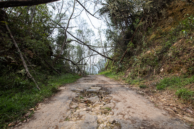
Start Walking! Although this is still technically a roadway, it gets pretty rough and doesn’t go much further. The rest of the way is by foot.
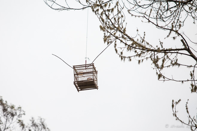
Dangerous Birdsong High over our heads on the steep path, a bird tied in a cage sang a sad song. The cage owner hoped this would attract other birds, who would then be captured and sold.
Cliffs and Climbing Before long, we left the last vestiges of roadway behind and clambered up a rocky crevice: not an easy feat when you are laden with camera gear!
Path through the Jungle At times, the path – and our guide with it – practically disappeared into the jungle growth.
Guide on the Path He kept his eyes on the surrounds as we climbed up the flank of the mountain.
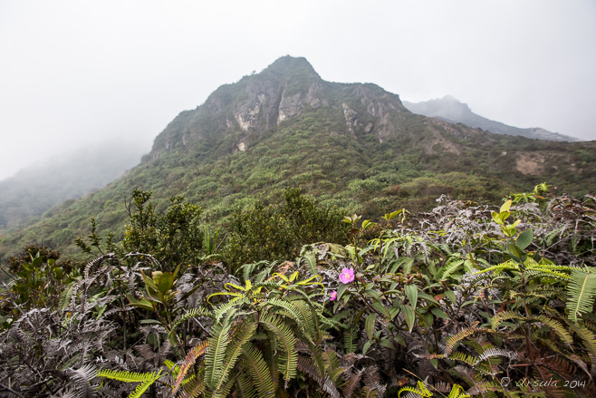
Indian Rhododendron Back in the open, the mountainside is covered in hardy flowering bushes, like the “Pride of India”(Melastoma melabathricum) …
Pitcher Plant … interspersed with delicate-looking but carnivorous Pitcher Plants(Nepenthes).
Coming Around the Mountain Our guide was continually on the lookout for plants we might find interesting.
Smoke in the Saddle As you come around the hill, the broken sides of the caldera come into view, and the smell of sulphur is stronger.
Smoke on the Mountain Steam rises from the vents; Mount Sibayak hasn’t erupted for more than a century, but it still gives rise to plenty of geothermal activity.
Sulphur on the Rocks The vents produce crystalline sulfur, which clings to the rocks and was once mined on a small scale.
Guide on the Rocks Our guide climbed over the sulphur-crusted rocks, looking for a good vent…
Burning Sulphur … to set a light to. Burning sulfur melts to a blood-red viscous liquid and runs over the rocks.
Graffiti in the Caldera Visitors have taken the time to sculpt designs and patterns on the volcano.
Caldera in the Mist The mountain rises up into the mists of sulphuric steam.
Cairns and Gardens Ferns and mosses take hold in gardens sculpted by visitors.
Ferns on the Wall
Flowers and Berries On the way back down the track, we notice different bushes.
Yellow Flowers Not all of the plants are “pretty”, but they all have their niche.
Thermal Pipes Driving to one of the many hot-spring bathing pools in the Berastagi area for a well-earned soak, we passed pipes boiling over with steam that was heading to the local power station.
There is nothing quite like soaking in a pool of mineral-laden hot-spring waters that have been piped in from the mountain you have just hiked!
Not particularly “eventful”, but interesting, and well worth the effort.
Hi Ursula. Thanks for sharing your experience hiking up to Mt. Sibayak. I’m planning a trip there soon and am wondering how to find a guide. Wasn’t able to find any online. Appreciate if you can give advice on how to find a reliable guide and if there’s any place in particular to stay at.
Hi Tiara,
I arranged our Sumatra trip through Adventure Indonesia and they took care of all the local guides. You might like to contact them.
There are a couple of big hotels and lots of small ones in Berastagi, and accommodation should be easy to find in any price range.
Cheers,
UrsulaReplyCancel
hock -May 23, 2018 - 6:46 am
ya please call/chat +6285270901937 for hike sibayak.ReplyCancel
Candle Heath (Richea continentis) Thriving in the sub-alpine bogs around the Guthega Pondage, the prickly candle heath was in full flower when we walked there late December.
It is supposed to be a nice summer walk to Mount Tate from Guthega Dam on the Snowy River in Australia’s High Country.
I wouldn’t know.
Three times I’ve driven over the bumpy dirt roads to Guthega, on the back side of Blue Cow Mountain, in search of the unmarked circuit through Consett Stephen Pass and across the Tate East Ridge. I have a book on Snowy Mountain Walks, published by the Geehi Bushwalking Club, and a husband who used to be and Eagle Scout, so finding a well-walked track should be easy.
But, no.
I can get lost in a car park, and my husband – in spite of his protestations – is not much better. I like to spend the change-of-year in the mountains (Alpine Bookends 2014) – after all, it is summertime in Australia. However, our attempt to make the Mount Tate circuit one of our last walks of December 2014, found us on a better-marked track, proceeding in pretty-much the opposite direction. We hiked south-east, from the closed and lonely-looking Guthega ski lodges, over the fens and bogs, to the privately owned (and also closed) Illawong Lodge.
Fortunately for us – while it wasn’t the walk we were aiming for – it is a delightful way to spend the afternoon.
Illawong Lodge Trail Head The first clue that were we on the “wrong” path should have been the fact that it was so clearly marked!
Illawong Lodge Trail The track leads southwest along the banks of the Snowy River, …
Alpine Mint Bush (Prostanthera Cuneata) … through sweet-smelling alpine mint, …
Candle Heath (Richea continentis) … and prickly clumps of candle heath.
Metal Bridge Metal grids take us over boggy creeks.
Bridge over Blue Cow Creek Built in 2010, the proper metal bridge eliminates the need for the old flying fox …
Flying Fox over Blue Cow Creek … which was used in the past to provide a safer option for crossing the rocks when the creek rose.
Flying Fox Erected by the Illawong Ski Tourers in 1961 and decommissioned in 2011, the old fox is now National-Trust listed.
Over the Snowy River Looking back over the Snowy River and Guthega Dam – part of the extensive Snowy Mountains Hydro Electric Scheme.
Snowy River Valley There’s not much water in the river – but you can be sure it’s cold!
Bog and Heath The sub-alpine ground is wet like a saturated sponge, complete with small “lakes” and puddles. Walkers do well to stay on the paths.
Steps Wooden steps divert water and protect the vegetation from run-off during the spring snow-melt.
Illawong Lodge The small hut on the hill has long been used as a winter base for ski clubs.
Illawong Lodge In 1956, the then-dilapidated hut was transformed into the present lodge. It is maintained by the Illawong Ski Tourers club. Although the National Trust lodge is for private use, there is emergency shelter at the back, underneath the main building.
Le Déjeuner sur l’Herbe Even without access to the inside, it is a lovely spot for a picnic in the grass and clover.
Alpine Hillside To return to Guthega car park, we retrace our steps through the fragrant scrub.
Buttercups It might be the same path, but we notice different things as we work our way across the hillsides.
Snow Gum (Eucalyptus pauciflora) Snow gums are nothing if not adaptable; this one stretches at ninety-degrees from the side of the hill, over the Snowy River below.
Snowy River The cold white water rushes over the rocks in the river bed.
Australian raven (Corvus coronoides) A raven welcomes us back to the patch of green below the car park.
That’s the beauty of walks in the Australian High Country –
No matter which one you are on, it’s a great way to finish up a wonderful year.
[…] at least one ambitious alpine walk (e.g.: Bookends on 2013, Alpine Bookends 2014, Illawong Lodge, Guthega, or Summer Walks in the High Country), but last summer we took it a bit easier. I […]ReplyCancel
[…] the sixteen major dams that make up the Snowy Mountains Hydroelectricity Scheme. We were attempting – not for the first time – to find the track to Mount […]ReplyCancel
Looking over Charlotte Pass The view from Mount Stillwell across the summer heath in Kosciuszko National Park.
The world has gone mad.
This last year has been a turbulent one: wars, acts of terror and insanity, massacres and tragedies – at home and overseas. The floods and droughts that accompany climactic extremes seem more common; the forced displacement of people is at its highest since the second world war; and the unprecedented ebola outbreak has claimed over 7000 lives.
Just this week, another passenger airplane has gone down…
Personally, I have been lucky. Although my family has experienced the ups and downs of unexpected marriages and splits, for the most part we have escaped the worst vagaries of misfortune. I have enjoyed a wonderful year, travelling and exploring on three continents with my husband, friends and family.
But, no man – nor any woman – is an island, and the news all around has indeed been distressing and depressing.
We all need an escape – a respite from the stress that the uncertainties in this modern world can induce. For me, that escape is in nature.
That is one of the reasons why I like to get away to the Australian Alps.
There is a stillness in the mountains. It helps me breathe. Centre. Refocus on all that is good…
So, the first and last days of 2014 found me – as is usual over the New Year’s break – in Kosciuszko National Park, walking through the snowless summer ski fields of Australia’s high country.
Early in January, my husband and I drove to Charlotte Pass to look over the Main Range, and to take a short walk up Mount Stillwell.
Out of Season The trail climbs up Mount Stillwell from the Charlotte Pass Lookout carpark, to the top of a forlorn chairlift. It was overcast, with intermittent rains, so we had the track almost to ourselves.
Alpine Shrubs Delicate sights and smells are all around.
Rocky Path It’s a charming – but moderately steep – climb up to the first lookout.
National Park Ranger My husband and I usually walk on our own, but every so often it is nice to have a NP Ranger along as an interpretive guide. As a local who’d lived in the area and worked with the National Parks many years, he was able to recount the varied interconnected changes wrought by recent differences in weather patterns. Australia’s alpine areas are particularly vulnerable to alterations in the length and timing of seasonal temperatures.
Roots on the Rocks As we climb out of the sub-alpine region into the alpine zone, vegetation is lower to the ground and hardier.
Alpine Meadows Delicate-looking but tough and resilient shrubs cover the hillside.
Silver Snow Daisies The colours of the heath are soft: the dusty blue-gray of the silver snow daisy leaves, red sheep sorrel flowers, and purple eyebright punctuate the hill.
Tiny Ground Cover
Shrubs in Flower Back down at the Charlotte Pass Lodge (1760m), we are again surrounded by sub-alpine shrubs and trees. The flowering season is brief – with late December through January usually the best time to catch the endemic blooms.
Snow Gum As the rain starts, the colours on the trunks of the snow gums (eucalyptus pauciflora) deepen.
[…] his protestations – is not much better. I like to spend the change-of-year in the mountains (Alpine Bookends 2014) – after all, it is summertime in Australia. However, our attempt to make the Mount Tate […]ReplyCancel
[…] “This last year has been a turbulent one: wars, acts of terror and insanity, massacres and t… Remove the ebola, which has finally been conquered, and add a devastating earthquake in Nepal, and it seems little has changed. […]ReplyCancel
[…] Park. Usually we plan at least one ambitious alpine walk (e.g.: Bookends on 2013, Alpine Bookends 2014, Illawong Lodge, Guthega, or Summer Walks in the High Country), but last summer we […]ReplyCancel
A good time to reconnect with family and loved ones, even though some might be far away, or missing completely.
An ideal time to reflect on the possibilities of love and peace – although the world at the moment seems to be providing few examples.
A good time to count one’s blessings, and, regardless of the hardships we might be facing, to be thankful for those opportunities and things we do have.
It’s not such a good time for the latest WordPress update – which doesn’t seem to allow me to upload photos in the relatively simple manner of old…
So, this will be brief: an afternoon’s sojourn into the Great Northern Desert of Rajasthan, a place where the air crackles with heat and hope, where life is hard (Life in the Thar Desert) and the nights are magic (Music and Magic). A place where, in the late afternoon, watching some men and their camels on the crest of a sandy hill, you can contemplate the rugged beauty of the place, and feel an expansive quietness – even while taking hundreds of pictures.
I will share only a few.
Camels on the Hill After a short camel ride over the dunes, we come into sight of another group of camels on the hills.
Three
Here comes our Guide!
That Look!
Regal Creature
A Boy and his Camel Children start work young – even if it seems to be a labour of love.
Afternoon Light
Camel Portrait
Waves in the Dunes
At Rest
Camels on the Crest Our local guide DV has a word to the camel drivers on the hill.
Walking the Camel
Camel in the Sunset One of the camel drivers canters across the sands against the lowering light.
Merry Christmas, Ursula. This week’s wanders is seasonal in a wonderful way, without snow, evergreens or feasting. It reflects one aspect of the multi – denominational or even the non – denominational nature of the date. I’m seeing caravans of camels snaking through the holy lands with exotic goods, beliefs and ideas; perhaps influencing a certain young, impressionable man, millenia ago. In my northrrn latitudes it the rebirth of the Sun that I celebrate. My Muslim, Punjabi, Christian and non-of-the-above friends all find reason to celebrate family, friends, prosperity and the promise of the end to the darkness at this time of year. Peace be with you!ReplyCancel
Merry Christmas, Thomas!
So nice to “see” you here on line.
I resisted including the photo I have of three wise women walking across the desert with metal pots on their heads. 😉
Best wishes for the New Year.ReplyCancel
I love the desert. I myself have also done in the Ra desert a tour on a camel. I wish you a great new year’s Eve and a healthy 2015 Ursula. Warm greetings DietmutReplyCancel
Rajasthani Gypsy Dancers Flickering light from a small fire in the temperate desert night, the haunting sounds of Indian woodwinds and syncopated drums, swirling dresses and rising song: it is a gypsy performance under the stars – guaranteed to make you smile.
Cool sands underfoot. Starry, wide-open skies overhead. Firelight and music and drums.
There is magic in the desert air.
“Midnight at the oasis Send your camel to bed Shadows paintin’ our faces Traces of romance in our heads…”
– Midnight at the Oasis by David Nichtern for Maria Muldaur
It was nighttime in the middle of the Thar Desert.
The Great Indian Thar Desert in northwestern India forms an expansive boundary with Pakistan. Also called the Marusthali, or “Land of the Dead” in Sanskrit, the region is none-the-less rich with its own unique life. My travel companions and I, with photographer Karl Grobl and local guide DV, had spent a fascinating day visiting with villagers in the heart of the arid, rolling dunes (see: Everyday Life in the Great Thar Desert), and were now reclined on chairs set deep into the sand.
Camels snorted in the shadows. The soft lamp-light from the tents in the background didn’t reach the low tables in front of us as we snacked on spicy nibbles we could barely see. Seated cross-legged on a concrete “performance space”, Rajasthani Kalbelia or Kabeliya men entertained us with the traditional music of the nomadic desert tribes: music played on the morchang, or jaw-harp; the sarangi, the most important stringed instrument in north-Indian folk music; the dufli or daf, a goat-skin tambourine; and various percussion instruments, including the dholak, or two-headed drum.
Rajasthani Gypsy Musicians Seated on the concrete “performance space”, musicians entertain us with plaintive melodies and syncopated beats.
Rajasthani Gypsy Musicians
Family of Kalbelia Dancers “Back stage”, two Kalbelia gypsy dancers and their young brother pose for pictures.
In the darkness behind the musicians, the evening’s “main attractions” – two Kalbelia gypsy dancers – were getting ready for their performance. With their younger brother and apprentice musician, they paused for photos in the dark, before their entrance onto the stage.
The songs and dances themselves are part of an oral tradition based on stories taken from folklore and mythology, and handed down through the generations. But neither the dances nor the songs are codified: the Kalbelia have a reputation for composing lyrics spontaneously and for creating improvisations between the dancers and the musicians.
Kalbelia Dancer The dancer weaves to the rhythm of the music – and the musicians follow her lead.
Gypsy Dancer In a swirl of skirts, with feet flashing, the dancer twirls…
Kalbelia Sisters … before being joined “on stage” by her sister …
Kalbelia Sisters … and spinning together with her. The flowing skirts are known for their intricate embroidery with silver thread and small mirrors.
Fire in the Foreground
Musicians Performing A male performer, keeping time with his rhythm sticks, sways gracefully as he sings traditional songs of the Bhopas, the another nomadic tribe. His companions accompany him on a matka, an earthenware pot; and a morchang, the plaintive desert mouth-harp.
Gypsy Backbend Kalbeliyan dancing requires a balance between suppleness and strength. When the women come back, they demonstrate their flexibility. The younger sister performs backbends …
Collecting Money … picking up money with her teeth.
Gypsy Backbend The elder sister goes one better …
Pick-up-Rings … and picks up rings with her eyes.
Portrait of a Dancer
Dancers Spinning Hands twisting gracefully, skirts flying, the sisters circle and spin…
Dancers Spinning … until they almost disappear.
Swirling Fabric
Dancer in Abstract
Black Swirl
A Dancer’s Smile
“… You don’t have to answer There’s no need to speak I’ll be your belly dancer, prancer And you can be my sheik.”
[…] crackles with heat and hope, where life is hard (Life in the Thar Desert) and the nights are magic (Music and Magic). A place where, in the late afternoon, watching some men and their camels on the crest of a sandy […]ReplyCancel
[…] We headed back to our camp for a dinner and entertainment under the stars: the nights are filled with traditional gypsy folk music and dance (Celebrating Music and Motion). […]ReplyCancel
- Performing the Ganga Aarti from Dasaswamedh Ghat, Varanasi
- Buddha Head from Shwedagon Pagoda, Myanmar
- Harry Clarke Window from Dingle, Ireland
- Novice Monk Shwe Yan Pyay Monastery, Myanmar
Packets of 10 for $AU50.
Or - pick any photo from my Flickr or Wanders blog photos.


 Music and magic in the night.


Hi Ursula. Thanks for sharing your experience hiking up to Mt. Sibayak. I’m planning a trip there soon and am wondering how to find a guide. Wasn’t able to find any online. Appreciate if you can give advice on how to find a reliable guide and if there’s any place in particular to stay at.
Thanks in advance!
Rgds,
Tiara
Hi Tiara,
I arranged our Sumatra trip through Adventure Indonesia and they took care of all the local guides. You might like to contact them.
There are a couple of big hotels and lots of small ones in Berastagi, and accommodation should be easy to find in any price range.
Cheers,
Ursula
ya please call/chat +6285270901937 for hike sibayak.